Limbuhan geodata
Limbuhan (Bicol) is a populated place; located in Philippines in Asia/Manila (GMT+8) time zone. With population of 3,191 people, there are 2319 cities with bigger population in this country. Compared to other cities in Philippines, 51.3% of cities are located further ↓South; 72.2% of cities are located further ←West and 97.1% of cities have higher elevation than Limbuhan. Note1
Administrative division(s):
- Level 1: Bicol
- Level 2: Province of Masbate
- Level 3: Pio V. Corpuz (Limbuhan)


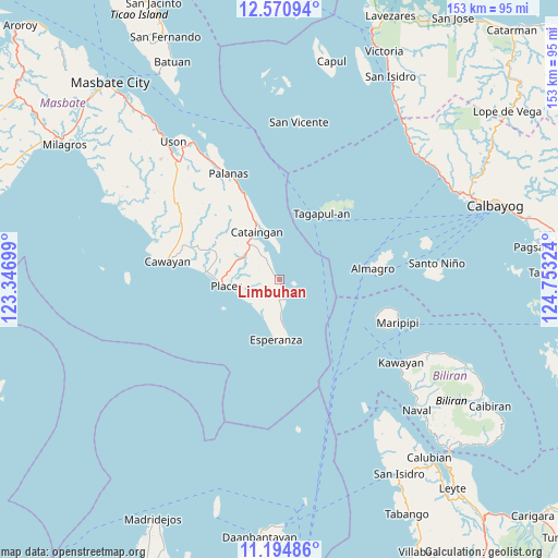
Limbuhan GPS coordinates[2]
11° 53' 1.572" North, 124° 3' 0.396" East
| Map corner | latitude | longitude |
|---|---|---|
| Upper-left | 12.57094°, | 123.34699° |
| Center: | 11.88377°, | 124.05011° |
| Lower-right: | 11.19486°, | 124.75324° |
| Map W x H: | 153×153 km | = 95.1×95.1mi |
| max Lat: | 20.78733° ⇑48.7% North |
| Limbuhan: | 11.88377° |
| min Lat: | ⇓51.3% South 4.65442° |
| min Long | Limbuhan | max Long |
| 117.04868° | 124.05011° | 126.58417° |
| W 72.2%⇐ | ⇒27.8% E |
Elevation
Elevation of Limbuhan is 4 m = 13 ft, and this is 83.9 m = 275 ft below average elevation for this country.
| Max E: |
2262 m = 7421 ft | 97.1% |
| Avg. | 87.9 m = 288 ft | |
| Limbuhan | 4 m = 13 ft | |
Min E: |
-2 m = -7 ft | 2.9% |
See also: Philippines elevation on elevation.city.
Geographical zone
Limbuhan is located in North Torrid zone (between Equator and Tropic of Cancer). Distance of this Northern Tropic circle is 1284.6 km =798.2 mi to North.| Distance of | km | miles | from Limbuhan |
|---|---|---|---|
| North Pole | 8685.7 | 5397 | to North |
| Arctic Circle | 6079.8 | 3777.8 | to North |
| Tropic Cancer | 1284.6 | 798.2 | to North |
| Equator | 1321.4 | 821.1 | to South |


Nearby cities:
15 places around Limbuhan: (largest is in red/bold)
• Almagro
25.8 km =16 mi,  83°
83°
• Cataingan
14.7 km =9.1 mi,  334°
334°
• Dimasalang
40.1 km =24.9 mi, 328°
• Esperanza
16.4 km =10.2 mi,  183°
183°
• Kawayan
40.4 km =25.1 mi,  124°
124°
• Maripipi
34.6 km =21.5 mi,  109°
109°
• Nabangig
26.3 km =16.3 mi,  335°
335°
• Naro
41 km =25.5 mi,  272°
272°
• Palanas
32.3 km =20.1 mi, 334°
• Pawican
22.9 km =14.2 mi, 337°
• Peña
25.9 km =16.1 mi, 331°
• Placer
14.4 km =8.9 mi,  263°
263°
• Recodo
34.8 km =21.6 mi,  282°
282°
• San Pedro
15.8 km =9.8 mi, 339°
• Tagapul-an
21.4 km =13.3 mi,  30°
30°
Sources, notices
• [Note1] Compared only with cities in Philippines existing in our database
• [Src1] Map data: © OpenStreetMap contributors (CC-BY-SA)
• [Src2] Other city data from geonames.org with taken over terms of usage.
• [Src3] Geographical zone / Annual Mean Temperature by Robert A. Rohde @ Wikipedia
