San Pedro geodata
San Pedro (Bicol) is a populated place; located in Philippines in Asia/Manila (GMT+8) time zone. With population of 2,318 people, there are 3637 cities with bigger population in this country. Compared to other cities in Philippines, 51.8% of cities are located further ↓South; 70.9% of cities are located further ←West and 89.7% of cities have higher elevation than San Pedro. Note1


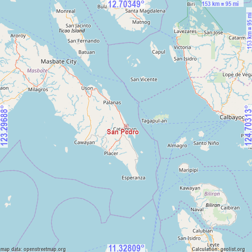
San Pedro GPS coordinates[2]
12° 1' 0.012" North, 124° 0' 0" East
| Map corner | latitude | longitude |
|---|---|---|
| Upper-left | 12.70349°, | 123.29688° |
| Center: | 12.01667°, | 124° |
| Lower-right: | 11.32809°, | 124.70313° |
| Map W x H: | 152.9×152.9 km | = 95×95mi |
| max Lat: | 20.78733° ⇑48.2% North |
| San Pedro: | 12.01667° |
| min Lat: | ⇓51.8% South 4.65442° |
| min Long | San Pedro | max Long |
| 117.04868° | 124° | 126.58417° |
| W 70.9%⇐ | ⇒29.1% E |
Elevation
Elevation of San Pedro is 7 m = 23 ft, and this is 80.9 m = 265 ft below average elevation for this country.
| Max E: |
2262 m = 7421 ft | 89.7% |
| Avg. | 87.9 m = 288 ft | |
| San Pedro | 7 m = 23 ft | |
Min E: |
-2 m = -7 ft | 10.3% |
See also: Philippines elevation on elevation.city.
Geographical zone
San Pedro is located in North Torrid zone (between Equator and Tropic of Cancer). Distance of this Northern Tropic circle is 1269.8 km =789 mi to North.| Distance of | km | miles | from San Pedro |
|---|---|---|---|
| North Pole | 8670.9 | 5387.8 | to North |
| Arctic Circle | 6065 | 3768.6 | to North |
| Tropic Cancer | 1269.8 | 789 | to North |
| Equator | 1336.1 | 830.2 | to South |


Nearby cities:
15 places around San Pedro: (largest is in red/bold)
• Balucawi
26.7 km =16.6 mi,  320°
320°
• Buenavista
28.9 km =18 mi,  307°
307°
• Cataingan
1.8 km =1.1 mi,  209°
209°
• Dimasalang
24.8 km =15.4 mi, 321°
• Esperanza
31.5 km =19.6 mi,  171°
171°
• Limbuhan
15.8 km =9.8 mi,  159°
159°
• Miaga
31.6 km =19.6 mi, 320°
• Nabangig
10.6 km =6.6 mi,  329°
329°
• Palanas
16.7 km =10.4 mi, 329°
• Pawican
7.1 km =4.4 mi, 333°
• Peña
10.5 km =6.5 mi, 320°
• Placer
18.7 km =11.6 mi, 208°
• Recodo
29.6 km =18.4 mi,  255°
255°
• San Vicente
30.3 km =18.8 mi,  21°
21°
• Tagapul-an
16.7 km =10.4 mi,  77°
77°
Sources, notices
• [Note1] Compared only with cities in Philippines existing in our database
• [Src1] Map data: © OpenStreetMap contributors (CC-BY-SA)
• [Src2] Other city data from geonames.org with taken over terms of usage.
• [Src3] Geographical zone / Annual Mean Temperature by Robert A. Rohde @ Wikipedia
