Peña geodata
Peña (Bicol) is a populated place; located in Philippines in Asia/Manila (GMT+8) time zone. With population of 2,537 people, there are 3232 cities with bigger population in this country. Compared to other cities in Philippines, 52.2% of cities are located further ↓South; 69.8% of cities are located further ←West and 87.8% of cities have lower elevation than Peña. Note1


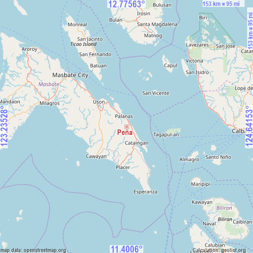
Peña GPS coordinates[2]
12° 5' 20.4" North, 123° 56' 18.24" East
| Map corner | latitude | longitude |
|---|---|---|
| Upper-left | 12.77563°, | 123.23528° |
| Center: | 12.089°, | 123.9384° |
| Lower-right: | 11.4006°, | 124.64153° |
| Map W x H: | 152.9×152.9 km | = 95×95mi |
| max Lat: | 20.78733° ⇑47.8% North |
| Peña: | 12.089° |
| min Lat: | ⇓52.2% South 4.65442° |
| min Long | Peña | max Long |
| 117.04868° | 123.9384° | 126.58417° |
| W 69.8%⇐ | ⇒30.2% E |
Elevation
Elevation of Peña is 178 m = 584 ft, and this is 90.1 m = 296 ft above average elevation for this country.
| Max E: |
2262 m = 7421 ft | 12.2% |
| Peña | 178 m 584 ft | |
| Avg. | 87.9 m = 288 ft | |
Min E: |
-2 m = -7 ft | 87.8% |
See also: Philippines elevation on elevation.city.
Geographical zone
Peña is located in North Torrid zone (between Equator and Tropic of Cancer). Distance of this Northern Tropic circle is 1261.7 km =784 mi to North.| Distance of | km | miles | from Peña |
|---|---|---|---|
| North Pole | 8662.9 | 5382.9 | to North |
| Arctic Circle | 6057 | 3763.6 | to North |
| Tropic Cancer | 1261.7 | 784 | to North |
| Equator | 1344.2 | 835.2 | to South |


Nearby cities:
15 places around Peña: (largest is in red/bold)
• Balucawi
16.3 km =10.1 mi,  320°
320°
• Buenavista
18.8 km =11.7 mi,  301°
301°
• Cataingan
11.2 km =7 mi,  148°
148°
• Dapdap
23.4 km =14.5 mi,  306°
306°
• Dimasalang
14.4 km =8.9 mi, 323°
• Limbuhan
25.9 km =16.1 mi, 151°
• Miaga
21.2 km =13.2 mi, 321°
• Nabangig
1.7 km =1.1 mi,  49°
49°
• Palanas
6.6 km =4.1 mi,  343°
343°
• Pawican
3.9 km =2.4 mi,  115°
115°
• Placer
24.6 km =15.3 mi,  185°
185°
• San Pedro
10.5 km =6.5 mi,  140°
140°
• San Vicente
26.8 km =16.7 mi,  40°
40°
• Tagapul-an
23.4 km =14.5 mi,  100°
100°
• Uson
22.7 km =14.1 mi, 311°
Sources, notices
• [Note1] Compared only with cities in Philippines existing in our database
• [Src1] Map data: © OpenStreetMap contributors (CC-BY-SA)
• [Src2] Other city data from geonames.org with taken over terms of usage.
• [Src3] Geographical zone / Annual Mean Temperature by Robert A. Rohde @ Wikipedia
