Tinagacan geodata
Tinagacan (Soccsksargen) is a populated place; located in Philippines in Asia/Manila (GMT+8) time zone. With population of 4,808 people, there are 1370 cities with bigger population in this country. Compared to other cities in Philippines, 97.2% of cities are located further ↑North; 90.5% of cities are located further ←West and 71.2% of cities have lower elevation than Tinagacan. Note1
Administrative division(s):
- Level 1: Soccsksargen
- Level 2: Province of South Cotabato
- Level 3: General Santos City (Dadiangas)


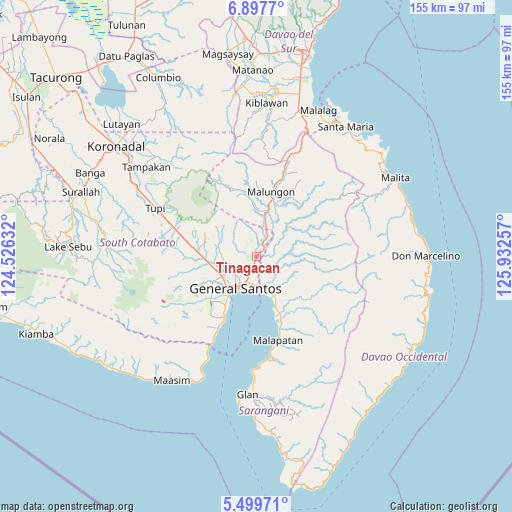
Tinagacan GPS coordinates[2]
6° 11' 57.012" North, 125° 13' 45.984" East
| Map corner | latitude | longitude |
|---|---|---|
| Upper-left | 6.8977°, | 124.52632° |
| Center: | 6.19917°, | 125.22944° |
| Lower-right: | 5.49971°, | 125.93257° |
| Map W x H: | 155.4×155.4 km | = 96.6×96.6mi |
| max Lat: | 20.78733° ⇑97.2% North |
| Tinagacan: | 6.19917° |
| min Lat: | ⇓2.8% South 4.65442° |
| min Long | Tinagacan | max Long |
| 117.04868° | 125.22944° | 126.58417° |
| W 90.5%⇐ | ⇒9.5% E |
Elevation
Elevation of Tinagacan is 55 m = 180 ft, and this is 32.9 m = 108 ft below average elevation for this country.
| Max E: |
2262 m = 7421 ft | 28.8% |
| Avg. | 87.9 m = 288 ft | |
| Tinagacan | 55 m = 180 ft | |
Min E: |
-2 m = -7 ft | 71.2% |
See also: Philippines elevation on elevation.city.
Geographical zone
Tinagacan is located in North Torrid zone (between Equator and Tropic of Cancer). Distance of Equator is 689.3 km =428.3 mi to South.| Distance of | km | miles | from Tinagacan |
|---|---|---|---|
| North Pole | 9317.8 | 5789.8 | to North |
| Arctic Circle | 6711.9 | 4170.6 | to North |
| Tropic Cancer | 1916.6 | 1190.9 | to North |
| Equator | 689.3 | 428.3 | to South |


Nearby cities:
15 places around Tinagacan: (largest is in red/bold)
• Alabel
12.8 km =8 mi,  148°
148°
• Batutitik
3.7 km =2.3 mi,  42°
42°
• Buayan
9.2 km =5.7 mi,  176°
176°
• Conel
4.7 km =2.9 mi,  274°
274°
• General Santos
11.5 km =7.1 mi,  213°
213°
• Glamang
16.6 km =10.3 mi,  255°
255°
• Katangawan
3.1 km =1.9 mi,  196°
196°
• Klinan
10.3 km =6.4 mi, 262°
• Malandag
12.5 km =7.8 mi,  9°
9°
• Maluñgun
10.6 km =6.6 mi,  32°
32°
• Manga
13.4 km =8.3 mi, 40°
• Polo
14.8 km =9.2 mi,  299°
299°
• Polomolok
18.5 km =11.5 mi,  277°
277°
• Silway 7
12.3 km =7.6 mi, 258°
• Upper Klinan
12.4 km =7.7 mi, 284°
Sources, notices
• [Note1] Compared only with cities in Philippines existing in our database
• [Src1] Map data: © OpenStreetMap contributors (CC-BY-SA)
• [Src2] Other city data from geonames.org with taken over terms of usage.
• [Src3] Geographical zone / Annual Mean Temperature by Robert A. Rohde @ Wikipedia
