Alabel geodata
Alabel (Soccsksargen) is a seat of a second-order administrative division; located in Philippines in Asia/Manila (GMT+8) time zone. With population of 43,312 people, there are 199 cities with bigger population in this country. Compared to other cities in Philippines, 97.4% of cities are located further ↑North; 91.3% of cities are located further ←West and 64.1% of cities have lower elevation than Alabel. Note1


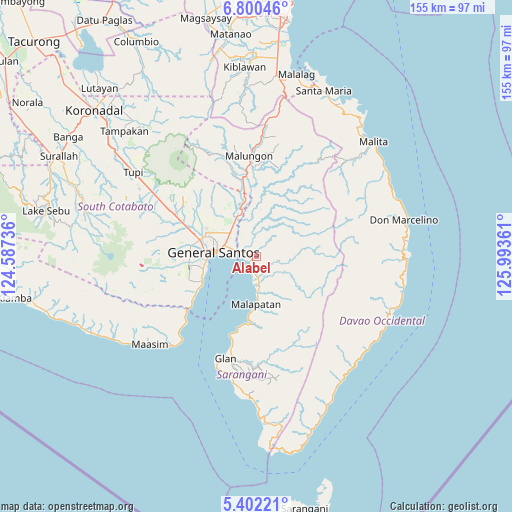
Alabel GPS coordinates[2]
6° 6' 6.444" North, 125° 17' 25.728" East
| Map corner | latitude | longitude |
|---|---|---|
| Upper-left | 6.80046°, | 124.58736° |
| Center: | 6.10179°, | 125.29048° |
| Lower-right: | 5.40221°, | 125.99361° |
| Map W x H: | 155.5×155.5 km | = 96.6×96.6mi |
| max Lat: | 20.78733° ⇑97.4% North |
| Alabel: | 6.10179° |
| min Lat: | ⇓2.6% South 4.65442° |
| min Long | Alabel | max Long |
| 117.04868° | 125.29048° | 126.58417° |
| W 91.3%⇐ | ⇒8.7% E |
Elevation
Elevation of Alabel is 40 m = 131 ft, and this is 47.9 m = 157 ft below average elevation for this country.
| Max E: |
2262 m = 7421 ft | 35.9% |
| Avg. | 87.9 m = 288 ft | |
| Alabel | 40 m = 131 ft | |
Min E: |
-2 m = -7 ft | 64.1% |
See also: Alabel elevation on elevation.city.
Geographical zone
Alabel is located in North Torrid zone (between Equator and Tropic of Cancer). Distance of Equator is 678.5 km =421.6 mi to South.| Distance of | km | miles | from Alabel |
|---|---|---|---|
| North Pole | 9328.6 | 5796.5 | to North |
| Arctic Circle | 6722.7 | 4177.3 | to North |
| Tropic Cancer | 1927.5 | 1197.7 | to North |
| Equator | 678.5 | 421.6 | to South |


Nearby cities:
15 places around Alabel: (largest is in red/bold)
• Batutitik
14.2 km =8.8 mi,  342°
342°
• Buayan
6.4 km =4 mi,  284°
284°
• Conel
16 km =9.9 mi,  314°
314°
• General Santos
13.2 km =8.2 mi, 275°
• Katangawan
10.9 km =6.8 mi,  315°
315°
• Klinan
19.4 km =12.1 mi,  299°
299°
• Lun Pequeño
7.2 km =4.5 mi,  185°
185°
• Malapatan
14.7 km =9.1 mi,  180°
180°
• Maluñgun
19.7 km =12.2 mi,  357°
357°
• Manga
21.1 km =13.1 mi,  5°
5°
• Sapu Padidu
20.7 km =12.9 mi, 187°
• Silway 7
20.6 km =12.8 mi,  294°
294°
• Suyan
11.5 km =7.1 mi,  113°
113°
• Tinagacan
12.8 km =8 mi,  328°
328°
• Tuyan
11.3 km =7 mi, 183°
Sources, notices
• [Note1] Compared only with cities in Philippines existing in our database
• [Src1] Map data: © OpenStreetMap contributors (CC-BY-SA)
• [Src2] Other city data from geonames.org with taken over terms of usage.
• [Src3] Geographical zone / Annual Mean Temperature by Robert A. Rohde @ Wikipedia
