Conel geodata
Conel (Soccsksargen) is a populated place; located in Philippines in Asia/Manila (GMT+8) time zone. With population of 8,519 people, there are 729 cities with bigger population in this country. Compared to other cities in Philippines, 97.1% of cities are located further ↑North; 90.1% of cities are located further ←West and 81.1% of cities have lower elevation than Conel. Note1
Administrative division(s):
- Level 1: Soccsksargen
- Level 2: Province of South Cotabato
- Level 3: General Santos City (Dadiangas)


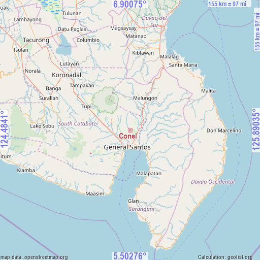
Conel GPS coordinates[2]
6° 12' 7.992" North, 125° 11' 13.992" East
| Map corner | latitude | longitude |
|---|---|---|
| Upper-left | 6.90075°, | 124.4841° |
| Center: | 6.20222°, | 125.18722° |
| Lower-right: | 5.50276°, | 125.89035° |
| Map W x H: | 155.4×155.4 km | = 96.6×96.6mi |
| max Lat: | 20.78733° ⇑97.1% North |
| Conel: | 6.20222° |
| min Lat: | ⇓2.9% South 4.65442° |
| min Long | Conel | max Long |
| 117.04868° | 125.18722° | 126.58417° |
| W 90.1%⇐ | ⇒9.9% E |
Elevation
Elevation of Conel is 100 m = 328 ft, and this is 12.1 m = 40 ft above average elevation for this country.
| Max E: |
2262 m = 7421 ft | 18.9% |
| Conel | 100 m 328 ft | |
| Avg. | 87.9 m = 288 ft | |
Min E: |
-2 m = -7 ft | 81.1% |
See also: Philippines elevation on elevation.city.
Geographical zone
Conel is located in North Torrid zone (between Equator and Tropic of Cancer). Distance of Equator is 689.6 km =428.5 mi to South.| Distance of | km | miles | from Conel |
|---|---|---|---|
| North Pole | 9317.4 | 5789.6 | to North |
| Arctic Circle | 6711.6 | 4170.4 | to North |
| Tropic Cancer | 1916.3 | 1190.7 | to North |
| Equator | 689.6 | 428.5 | to South |


Nearby cities:
15 places around Conel: (largest is in red/bold)
• Alabel
16 km =9.9 mi,  134°
134°
• Batutitik
7.5 km =4.7 mi,  71°
71°
• Buayan
10.9 km =6.8 mi,  151°
151°
• General Santos
10.1 km =6.3 mi,  189°
189°
• Glamang
12.2 km =7.6 mi,  248°
248°
• Katangawan
5 km =3.1 mi, 131°
• Klinan
5.8 km =3.6 mi, 252°
• Malandag
13.7 km =8.5 mi,  29°
29°
• Maluñgun
13.5 km =8.4 mi,  50°
50°
• Manga
16.6 km =10.3 mi, 53°
• Polo
10.8 km =6.7 mi,  310°
310°
• Polomolok
13.8 km =8.6 mi,  279°
279°
• Silway 7
7.9 km =4.9 mi, 249°
• Tinagacan
4.7 km =2.9 mi,  94°
94°
• Upper Klinan
7.8 km =4.8 mi,  290°
290°
Sources, notices
• [Note1] Compared only with cities in Philippines existing in our database
• [Src1] Map data: © OpenStreetMap contributors (CC-BY-SA)
• [Src2] Other city data from geonames.org with taken over terms of usage.
• [Src3] Geographical zone / Annual Mean Temperature by Robert A. Rohde @ Wikipedia
