Buayan geodata
Buayan (Soccsksargen) is a populated place; located in Philippines in Asia/Manila (GMT+8) time zone. With population of 14,607 people, there are 458 cities with bigger population in this country. Compared to other cities in Philippines, 97.3% of cities are located further ↑North; 90.6% of cities are located further ←West and 67.4% of cities have higher elevation than Buayan. Note1
Administrative division(s):
- Level 1: Soccsksargen
- Level 2: Province of South Cotabato
- Level 3: General Santos City (Dadiangas)


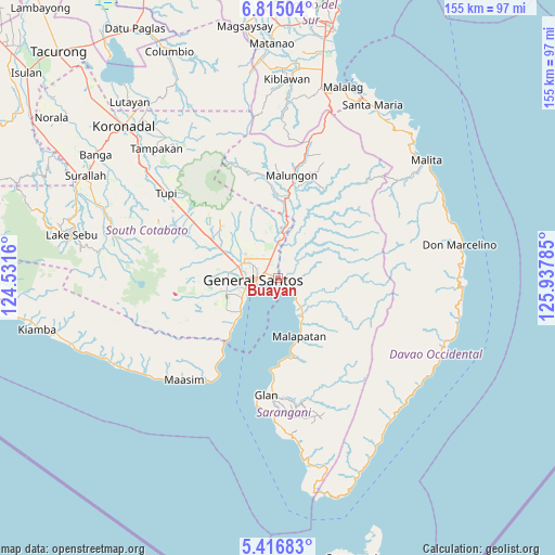
Buayan GPS coordinates[2]
6° 6' 59.004" North, 125° 14' 4.992" East
| Map corner | latitude | longitude |
|---|---|---|
| Upper-left | 6.81504°, | 124.5316° |
| Center: | 6.11639°, | 125.23472° |
| Lower-right: | 5.41683°, | 125.93785° |
| Map W x H: | 155.5×155.5 km | = 96.6×96.6mi |
| max Lat: | 20.78733° ⇑97.3% North |
| Buayan: | 6.11639° |
| min Lat: | ⇓2.7% South 4.65442° |
| min Long | Buayan | max Long |
| 117.04868° | 125.23472° | 126.58417° |
| W 90.6%⇐ | ⇒9.4% E |
Elevation
Elevation of Buayan is 13 m = 43 ft, and this is 74.9 m = 246 ft below average elevation for this country.
| Max E: |
2262 m = 7421 ft | 67.4% |
| Avg. | 87.9 m = 288 ft | |
| Buayan | 13 m = 43 ft | |
Min E: |
-2 m = -7 ft | 32.6% |
See also: Philippines elevation on elevation.city.
Geographical zone
Buayan is located in North Torrid zone (between Equator and Tropic of Cancer). Distance of Equator is 680.1 km =422.6 mi to South.| Distance of | km | miles | from Buayan |
|---|---|---|---|
| North Pole | 9327 | 5795.5 | to North |
| Arctic Circle | 6721.1 | 4176.3 | to North |
| Tropic Cancer | 1925.8 | 1196.6 | to North |
| Equator | 680.1 | 422.6 | to South |


Nearby cities:
15 places around Buayan: (largest is in red/bold)
• Alabel
6.4 km =4 mi,  104°
104°
• Batutitik
12 km =7.5 mi,  9°
9°
• Conel
10.9 km =6.8 mi,  331°
331°
• General Santos
7 km =4.3 mi,  266°
266°
• Glamang
17.4 km =10.8 mi,  287°
287°
• Katangawan
6.4 km =4 mi,  346°
346°
• Klinan
13.4 km =8.3 mi,  305°
305°
• Lun Pequeño
10.3 km =6.4 mi,  148°
148°
• Malapatan
17.5 km =10.9 mi,  159°
159°
• Maluñgun
18.8 km =11.7 mi,  15°
15°
• Silway 7
14.3 km =8.9 mi,  298°
298°
• Suyan
17.8 km =11.1 mi,  110°
110°
• Tinagacan
9.2 km =5.7 mi,  356°
356°
• Tuyan
14 km =8.7 mi, 157°
• Upper Klinan
17.6 km =10.9 mi, 314°
Sources, notices
• [Note1] Compared only with cities in Philippines existing in our database
• [Src1] Map data: © OpenStreetMap contributors (CC-BY-SA)
• [Src2] Other city data from geonames.org with taken over terms of usage.
• [Src3] Geographical zone / Annual Mean Temperature by Robert A. Rohde @ Wikipedia
