Katangawan geodata
Katangawan (Soccsksargen) is a populated place; located in Philippines in Asia/Manila (GMT+8) time zone. With population of 8,476 people, there are 732 cities with bigger population in this country. Compared to other cities in Philippines, 97.2% of cities are located further ↑North; 90.4% of cities are located further ←West and 62.9% of cities have lower elevation than Katangawan. Note1
Administrative division(s):
- Level 1: Soccsksargen
- Level 2: Province of South Cotabato
- Level 3: General Santos City (Dadiangas)


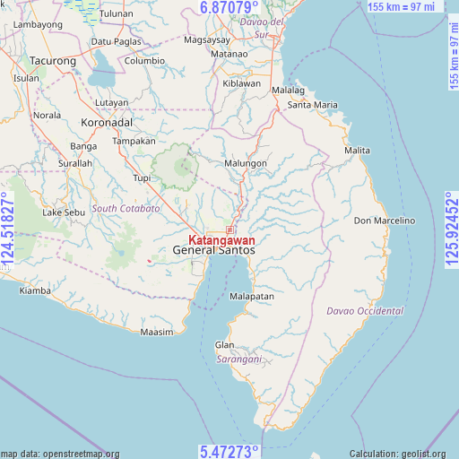
Katangawan GPS coordinates[2]
6° 10' 19.992" North, 125° 13' 17.004" East
| Map corner | latitude | longitude |
|---|---|---|
| Upper-left | 6.87079°, | 124.51827° |
| Center: | 6.17222°, | 125.22139° |
| Lower-right: | 5.47273°, | 125.92452° |
| Map W x H: | 155.4×155.5 km | = 96.6×96.6mi |
| max Lat: | 20.78733° ⇑97.2% North |
| Katangawan: | 6.17222° |
| min Lat: | ⇓2.8% South 4.65442° |
| min Long | Katangawan | max Long |
| 117.04868° | 125.22139° | 126.58417° |
| W 90.4%⇐ | ⇒9.6% E |
Elevation
Elevation of Katangawan is 38 m = 125 ft, and this is 49.9 m = 164 ft below average elevation for this country.
| Max E: |
2262 m = 7421 ft | 37.1% |
| Avg. | 87.9 m = 288 ft | |
| Katangawan | 38 m = 125 ft | |
Min E: |
-2 m = -7 ft | 62.9% |
See also: Philippines elevation on elevation.city.
Geographical zone
Katangawan is located in North Torrid zone (between Equator and Tropic of Cancer). Distance of Equator is 686.3 km =426.4 mi to South.| Distance of | km | miles | from Katangawan |
|---|---|---|---|
| North Pole | 9320.8 | 5791.7 | to North |
| Arctic Circle | 6714.9 | 4172.4 | to North |
| Tropic Cancer | 1919.6 | 1192.8 | to North |
| Equator | 686.3 | 426.4 | to South |


Nearby cities:
15 places around Katangawan: (largest is in red/bold)
• Alabel
10.9 km =6.8 mi,  135°
135°
• Batutitik
6.6 km =4.1 mi,  30°
30°
• Buayan
6.4 km =4 mi,  166°
166°
• Conel
5 km =3.1 mi,  311°
311°
• General Santos
8.6 km =5.3 mi,  219°
219°
• Glamang
15.2 km =9.4 mi,  265°
265°
• Klinan
9.5 km =5.9 mi,  279°
279°
• Lun Pequeño
16.5 km =10.3 mi,  155°
155°
• Malandag
15.6 km =9.7 mi,  10°
10°
• Maluñgun
13.6 km =8.5 mi, 29°
• Manga
16.3 km =10.1 mi,  36°
36°
• Polo
15.8 km =9.8 mi, 310°
• Silway 7
11.1 km =6.9 mi, 272°
• Tinagacan
3.1 km =1.9 mi,  16°
16°
• Upper Klinan
12.7 km =7.9 mi,  298°
298°
Sources, notices
• [Note1] Compared only with cities in Philippines existing in our database
• [Src1] Map data: © OpenStreetMap contributors (CC-BY-SA)
• [Src2] Other city data from geonames.org with taken over terms of usage.
• [Src3] Geographical zone / Annual Mean Temperature by Robert A. Rohde @ Wikipedia
