General Santos geodata
General Santos (Soccsksargen) is a populated place; located in Philippines in Asia/Manila (GMT+8) time zone. With population of 679,588 people, there are 7 cities with bigger population in this country. Compared to other cities in Philippines, 97.4% of cities are located further ↑North; 90% of cities are located further ←West and 51.8% of cities have higher elevation than General Santos. Note1
Administrative division(s):
- Level 1: Soccsksargen
- Level 2: Province of South Cotabato
- Level 3: General Santos City (Dadiangas)


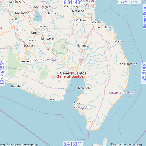
General Santos GPS coordinates[2]
6° 6' 46.008" North, 125° 10' 18.012" East
| Map corner | latitude | longitude |
|---|---|---|
| Upper-left | 6.81143°, | 124.46855° |
| Center: | 6.11278°, | 125.17167° |
| Lower-right: | 5.41321°, | 125.8748° |
| Map W x H: | 155.5×155.5 km | = 96.6×96.6mi |
| max Lat: | 20.78733° ⇑97.4% North |
| General Santos: | 6.11278° |
| min Lat: | ⇓2.6% South 4.65442° |
| min Long | General Santos | max Long |
| 117.04868° | 125.17167° | 126.58417° |
| W 90%⇐ | ⇒10% E |
Elevation
Elevation of General Santos is 22 m = 72 ft, and this is 65.9 m = 216 ft below average elevation for this country.
| Max E: |
2262 m = 7421 ft | 51.8% |
| Avg. | 87.9 m = 288 ft | |
| General Santos | 22 m = 72 ft | |
Min E: |
-2 m = -7 ft | 48.2% |
See also: General Santos elevation on elevation.city.
Geographical zone
General Santos is located in North Torrid zone (between Equator and Tropic of Cancer). Distance of Equator is 679.7 km =422.3 mi to South.| Distance of | km | miles | from General Santos |
|---|---|---|---|
| North Pole | 9327.4 | 5795.8 | to North |
| Arctic Circle | 6721.5 | 4176.5 | to North |
| Tropic Cancer | 1926.2 | 1196.9 | to North |
| Equator | 679.7 | 422.3 | to South |


Nearby cities:
15 places around General Santos: (largest is in red/bold)
• Alabel
13.2 km =8.2 mi,  95°
95°
• Batutitik
15.2 km =9.4 mi,  35°
35°
• Buayan
7 km =4.3 mi,  86°
86°
• Conel
10.1 km =6.3 mi,  9°
9°
• Glamang
11.2 km =7 mi,  299°
299°
• Katangawan
8.6 km =5.3 mi, 39°
• Klinan
9.1 km =5.7 mi,  334°
334°
• Lun Pequeño
14.9 km =9.3 mi,  123°
123°
• Malapatan
20.6 km =12.8 mi,  140°
140°
• Polo
18.1 km =11.2 mi,  338°
338°
• Polomolok
17 km =10.6 mi,  315°
315°
• Silway 7
9.1 km =5.7 mi, 321°
• Tinagacan
11.5 km =7.1 mi,  33°
33°
• Tuyan
17.6 km =10.9 mi, 135°
• Upper Klinan
13.9 km =8.6 mi, 336°
Sources, notices
• [Note1] Compared only with cities in Philippines existing in our database
• [Src1] Map data: © OpenStreetMap contributors (CC-BY-SA)
• [Src2] Other city data from geonames.org with taken over terms of usage.
• [Src3] Geographical zone / Annual Mean Temperature by Robert A. Rohde @ Wikipedia
