La Roxas geodata
La Roxas (Northern Mindanao) is a populated place; located in Philippines in Asia/Manila (GMT+8) time zone. With population of 2,456 people, there are 3369 cities with bigger population in this country. Compared to other cities in Philippines, 83.7% of cities are located further ↑North; 86% of cities are located further ←West and 98.8% of cities have lower elevation than La Roxas. Note1
Administrative division(s):
- Level 1: Northern Mindanao
- Level 2: Province of Bukidnon
- Level 3: Maramag


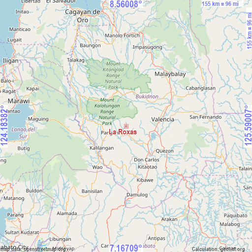
La Roxas GPS coordinates[2]
7° 51' 51.012" North, 124° 53' 12.984" East
| Map corner | latitude | longitude |
|---|---|---|
| Upper-left | 8.56008°, | 124.18382° |
| Center: | 7.86417°, | 124.88694° |
| Lower-right: | 7.16709°, | 125.59007° |
| Map W x H: | 154.9×154.9 km | = 96.3×96.3mi |
| max Lat: | 20.78733° ⇑83.7% North |
| La Roxas: | 7.86417° |
| min Lat: | ⇓16.3% South 4.65442° |
| min Long | La Roxas | max Long |
| 117.04868° | 124.88694° | 126.58417° |
| W 86%⇐ | ⇒14% E |
Elevation
Elevation of La Roxas is 891 m = 2923 ft, and this is 803.1 m = 2635 ft above average elevation for this country.
| Max E: |
2262 m = 7421 ft | 1.2% |
| La Roxas | 891 m 2923 ft | |
| Avg. | 87.9 m = 288 ft | |
Min E: |
-2 m = -7 ft | 98.8% |
See also: Philippines elevation on elevation.city.
Geographical zone
La Roxas is located in North Torrid zone (between Equator and Tropic of Cancer). Distance of Equator is 874.4 km =543.3 mi to South.| Distance of | km | miles | from La Roxas |
|---|---|---|---|
| North Pole | 9132.6 | 5674.7 | to North |
| Arctic Circle | 6526.8 | 4055.6 | to North |
| Tropic Cancer | 1731.5 | 1075.9 | to North |
| Equator | 874.4 | 543.3 | to South |


Nearby cities:
15 places around La Roxas: (largest is in red/bold)
• Adtugan
6.8 km =4.2 mi,  211°
211°
• Alanib
21.2 km =13.2 mi,  30°
30°
• Balila
20.7 km =12.9 mi,  42°
42°
• Bangahan
18.5 km =11.5 mi,  245°
245°
• Basak
19.9 km =12.4 mi,  352°
352°
• Dologon
17.5 km =10.9 mi,  98°
98°
• Kalilangan
20.3 km =12.6 mi,  229°
229°
• Kibangay
20.6 km =12.8 mi,  1°
1°
• Kimanuit
21.2 km =13.2 mi,  237°
237°
• Lantapan
21.5 km =13.4 mi,  46°
46°
• Lurugan
19.1 km =11.9 mi, 27°
• Maramag
17.2 km =10.7 mi,  130°
130°
• NIA Valencia
23.3 km =14.5 mi,  78°
78°
• Pangantocan
8.4 km =5.2 mi,  257°
257°
• San Carlos
23.5 km =14.6 mi,  63°
63°
Sources, notices
• [Note1] Compared only with cities in Philippines existing in our database
• [Src1] Map data: © OpenStreetMap contributors (CC-BY-SA)
• [Src2] Other city data from geonames.org with taken over terms of usage.
• [Src3] Geographical zone / Annual Mean Temperature by Robert A. Rohde @ Wikipedia
