Kalilangan geodata
Kalilangan (Northern Mindanao) is a populated place; located in Philippines in Asia/Manila (GMT+8) time zone. With population of 14,456 people, there are 462 cities with bigger population in this country. Compared to other cities in Philippines, 84.8% of cities are located further ↑North; 83.1% of cities are located further ←West and 98.7% of cities have lower elevation than Kalilangan. Note1
Administrative division(s):
- Level 1: Northern Mindanao
- Level 2: Province of Bukidnon
- Level 3: Kalilangan


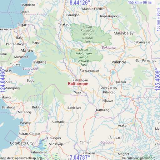
Kalilangan GPS coordinates[2]
7° 44' 42.504" North, 124° 44' 51.972" East
| Map corner | latitude | longitude |
|---|---|---|
| Upper-left | 8.44126°, | 124.04465° |
| Center: | 7.74514°, | 124.74777° |
| Lower-right: | 7.04787°, | 125.4509° |
| Map W x H: | 154.9×154.9 km | = 96.3×96.3mi |
| max Lat: | 20.78733° ⇑84.8% North |
| Kalilangan: | 7.74514° |
| min Lat: | ⇓15.2% South 4.65442° |
| min Long | Kalilangan | max Long |
| 117.04868° | 124.74777° | 126.58417° |
| W 83.1%⇐ | ⇒16.9% E |
Elevation
Elevation of Kalilangan is 874 m = 2867 ft, and this is 786.1 m = 2579 ft above average elevation for this country.
| Max E: |
2262 m = 7421 ft | 1.3% |
| Kalilangan | 874 m 2867 ft | |
| Avg. | 87.9 m = 288 ft | |
Min E: |
-2 m = -7 ft | 98.7% |
See also: Philippines elevation on elevation.city.
Geographical zone
Kalilangan is located in North Torrid zone (between Equator and Tropic of Cancer). Distance of Equator is 861.2 km =535.1 mi to South.| Distance of | km | miles | from Kalilangan |
|---|---|---|---|
| North Pole | 9145.9 | 5683 | to North |
| Arctic Circle | 6540 | 4063.8 | to North |
| Tropic Cancer | 1744.7 | 1084.1 | to North |
| Equator | 861.2 | 535.1 | to South |


Nearby cities:
15 places around Kalilangan: (largest is in red/bold)
• Adtugan
13.9 km =8.6 mi,  57°
57°
• Bangahan
5.9 km =3.7 mi,  344°
344°
• Banisilan
28.4 km =17.6 mi,  185°
185°
• Bumbaran
12.4 km =7.7 mi,  299°
299°
• Don Carlos
29.3 km =18.2 mi,  104°
104°
• Kadingilan
23.9 km =14.9 mi,  132°
132°
• Kimanuit
3 km =1.9 mi, 304°
• Kitaotao
31.1 km =19.3 mi,  112°
112°
• La Roxas
20.3 km =12.6 mi,  49°
49°
• Malinao
21 km =13 mi, 191°
• Maramag
28.4 km =17.6 mi,  85°
85°
• Osias
17.8 km =11.1 mi,  154°
154°
• Pangantocan
13.4 km =8.3 mi,  32°
32°
• San Miguel
31.7 km =19.7 mi,  1°
1°
• Wao
11.3 km =7 mi,  232°
232°
Sources, notices
• [Note1] Compared only with cities in Philippines existing in our database
• [Src1] Map data: © OpenStreetMap contributors (CC-BY-SA)
• [Src2] Other city data from geonames.org with taken over terms of usage.
• [Src3] Geographical zone / Annual Mean Temperature by Robert A. Rohde @ Wikipedia
