Bangahan geodata
Bangahan (Northern Mindanao) is a populated place; located in Philippines in Asia/Manila (GMT+8) time zone. With population of 2,728 people, there are 2897 cities with bigger population in this country. Compared to other cities in Philippines, 84.3% of cities are located further ↑North; 82.9% of cities are located further ←West and 98.2% of cities have lower elevation than Bangahan. Note1
Administrative division(s):
- Level 1: Northern Mindanao
- Level 2: Province of Bukidnon
- Level 3: Kalilangan


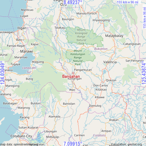
Bangahan GPS coordinates[2]
7° 47' 46.824" North, 124° 44' 0.996" East
| Map corner | latitude | longitude |
|---|---|---|
| Upper-left | 8.49237°, | 124.03049° |
| Center: | 7.79634°, | 124.73361° |
| Lower-right: | 7.09915°, | 125.43674° |
| Map W x H: | 154.9×154.9 km | = 96.3×96.3mi |
| max Lat: | 20.78733° ⇑84.3% North |
| Bangahan: | 7.79634° |
| min Lat: | ⇓15.7% South 4.65442° |
| min Long | Bangahan | max Long |
| 117.04868° | 124.73361° | 126.58417° |
| W 82.9%⇐ | ⇒17.1% E |
Elevation
Elevation of Bangahan is 775 m = 2543 ft, and this is 687.1 m = 2254 ft above average elevation for this country.
| Max E: |
2262 m = 7421 ft | 1.8% |
| Bangahan | 775 m 2543 ft | |
| Avg. | 87.9 m = 288 ft | |
Min E: |
-2 m = -7 ft | 98.2% |
See also: Philippines elevation on elevation.city.
Geographical zone
Bangahan is located in North Torrid zone (between Equator and Tropic of Cancer). Distance of Equator is 866.9 km =538.7 mi to South.| Distance of | km | miles | from Bangahan |
|---|---|---|---|
| North Pole | 9140.2 | 5679.5 | to North |
| Arctic Circle | 6534.3 | 4060.2 | to North |
| Tropic Cancer | 1739 | 1080.6 | to North |
| Equator | 866.9 | 538.7 | to South |


Nearby cities:
15 places around Bangahan: (largest is in red/bold)
• Adtugan
13.4 km =8.3 mi,  82°
82°
• Basak
30.7 km =19.1 mi,  27°
27°
• Bumbaran
9.2 km =5.7 mi,  272°
272°
• Don Carlos
32.6 km =20.3 mi,  113°
113°
• Kadingilan
29 km =18 mi,  138°
138°
• Kalilangan
5.9 km =3.7 mi,  164°
164°
• Kimanuit
4.1 km =2.5 mi,  193°
193°
• La Roxas
18.5 km =11.5 mi,  65°
65°
• Malinao
26.4 km =16.4 mi, 186°
• Maramag
30.2 km =18.8 mi,  96°
96°
• Osias
23.7 km =14.7 mi, 157°
• Pangantocan
10.4 km =6.5 mi,  56°
56°
• San Miguel
26.1 km =16.2 mi,  4°
4°
• Ticala-an
29.3 km =18.2 mi,  334°
334°
• Wao
14.6 km =9.1 mi,  210°
210°
Sources, notices
• [Note1] Compared only with cities in Philippines existing in our database
• [Src1] Map data: © OpenStreetMap contributors (CC-BY-SA)
• [Src2] Other city data from geonames.org with taken over terms of usage.
• [Src3] Geographical zone / Annual Mean Temperature by Robert A. Rohde @ Wikipedia
