Adtugan geodata
Adtugan (Northern Mindanao) is a populated place; located in Philippines in Asia/Manila (GMT+8) time zone. With population of 3,380 people, there are 2156 cities with bigger population in this country. Compared to other cities in Philippines, 84.2% of cities are located further ↑North; 85.5% of cities are located further ←West and 97.2% of cities have lower elevation than Adtugan. Note1
Administrative division(s):
- Level 1: Northern Mindanao
- Level 2: Province of Bukidnon
- Level 3: Pangantucan


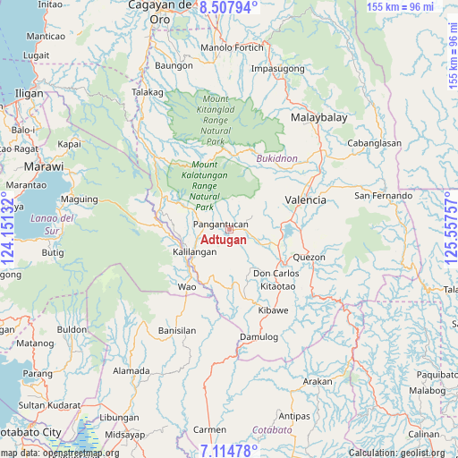
Adtugan GPS coordinates[2]
7° 48' 42.984" North, 124° 51' 15.984" East
| Map corner | latitude | longitude |
|---|---|---|
| Upper-left | 8.50794°, | 124.15132° |
| Center: | 7.81194°, | 124.85444° |
| Lower-right: | 7.11478°, | 125.55757° |
| Map W x H: | 154.9×154.9 km | = 96.3×96.3mi |
| max Lat: | 20.78733° ⇑84.2% North |
| Adtugan: | 7.81194° |
| min Lat: | ⇓15.8% South 4.65442° |
| min Long | Adtugan | max Long |
| 117.04868° | 124.85444° | 126.58417° |
| W 85.5%⇐ | ⇒14.5% E |
Elevation
Elevation of Adtugan is 650 m = 2133 ft, and this is 562.1 m = 1844 ft above average elevation for this country.
| Max E: |
2262 m = 7421 ft | 2.8% |
| Adtugan | 650 m 2133 ft | |
| Avg. | 87.9 m = 288 ft | |
Min E: |
-2 m = -7 ft | 97.2% |
See also: Philippines elevation on elevation.city.
Geographical zone
Adtugan is located in North Torrid zone (between Equator and Tropic of Cancer). Distance of Equator is 868.6 km =539.7 mi to South.| Distance of | km | miles | from Adtugan |
|---|---|---|---|
| North Pole | 9138.5 | 5678.4 | to North |
| Arctic Circle | 6532.6 | 4059.2 | to North |
| Tropic Cancer | 1737.3 | 1079.5 | to North |
| Equator | 868.6 | 539.7 | to South |


Nearby cities:
15 places around Adtugan: (largest is in red/bold)
• Bangahan
13.4 km =8.3 mi,  262°
262°
• Basak
25.5 km =15.8 mi,  2°
2°
• Bumbaran
22.6 km =14 mi,  266°
266°
• Dologon
21.2 km =13.2 mi,  81°
81°
• Don Carlos
22.1 km =13.7 mi,  131°
131°
• Kadingilan
24.2 km =15 mi,  165°
165°
• Kalilangan
13.9 km =8.6 mi,  237°
237°
• Kimanuit
15.4 km =9.6 mi,  248°
248°
• Kitaotao
25.6 km =15.9 mi,  138°
138°
• La Roxas
6.8 km =4.2 mi,  31°
31°
• Maramag
17.5 km =10.9 mi,  108°
108°
• Osias
23.9 km =14.9 mi,  190°
190°
• Pangantocan
6.1 km =3.8 mi,  310°
310°
• San Jose
25.2 km =15.7 mi, 109°
• Wao
25.1 km =15.6 mi, 235°
Sources, notices
• [Note1] Compared only with cities in Philippines existing in our database
• [Src1] Map data: © OpenStreetMap contributors (CC-BY-SA)
• [Src2] Other city data from geonames.org with taken over terms of usage.
• [Src3] Geographical zone / Annual Mean Temperature by Robert A. Rohde @ Wikipedia
