Klinan geodata
Klinan (Soccsksargen) is a populated place; located in Philippines in Asia/Manila (GMT+8) time zone. With population of 3,017 people, there are 2507 cities with bigger population in this country. Compared to other cities in Philippines, 97.2% of cities are located further ↑North; 89.7% of cities are located further ←West and 86.9% of cities have lower elevation than Klinan. Note1
Administrative division(s):
- Level 1: Soccsksargen
- Level 2: Province of South Cotabato
- Level 3: Polomolok


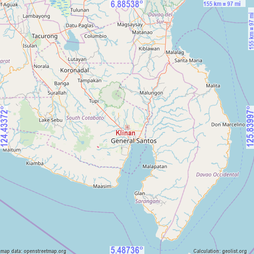
Klinan GPS coordinates[2]
6° 11' 12.588" North, 125° 8' 12.624" East
| Map corner | latitude | longitude |
|---|---|---|
| Upper-left | 6.88538°, | 124.43372° |
| Center: | 6.18683°, | 125.13684° |
| Lower-right: | 5.48736°, | 125.83997° |
| Map W x H: | 155.4×155.4 km | = 96.6×96.6mi |
| max Lat: | 20.78733° ⇑97.2% North |
| Klinan: | 6.18683° |
| min Lat: | ⇓2.8% South 4.65442° |
| min Long | Klinan | max Long |
| 117.04868° | 125.13684° | 126.58417° |
| W 89.7%⇐ | ⇒10.3% E |
Elevation
Elevation of Klinan is 165 m = 541 ft, and this is 77.1 m = 253 ft above average elevation for this country.
| Max E: |
2262 m = 7421 ft | 13.1% |
| Klinan | 165 m 541 ft | |
| Avg. | 87.9 m = 288 ft | |
Min E: |
-2 m = -7 ft | 86.9% |
See also: Philippines elevation on elevation.city.
Geographical zone
Klinan is located in North Torrid zone (between Equator and Tropic of Cancer). Distance of Equator is 687.9 km =427.4 mi to South.| Distance of | km | miles | from Klinan |
|---|---|---|---|
| North Pole | 9319.2 | 5790.7 | to North |
| Arctic Circle | 6713.3 | 4171.4 | to North |
| Tropic Cancer | 1918 | 1191.8 | to North |
| Equator | 687.9 | 427.4 | to South |


Nearby cities:
15 places around Klinan: (largest is in red/bold)
• Batutitik
13.4 km =8.3 mi,  72°
72°
• Buayan
13.4 km =8.3 mi,  125°
125°
• Conel
5.8 km =3.6 mi, 72°
• General Santos
9.1 km =5.7 mi,  154°
154°
• Glamang
6.4 km =4 mi,  245°
245°
• Katangawan
9.5 km =5.9 mi,  99°
99°
• Koronadal
17.7 km =11 mi,  291°
291°
• Pagalungan
16.2 km =10.1 mi,  302°
302°
• Palkan
16.8 km =10.4 mi,  316°
316°
• Polo
9.1 km =5.7 mi,  342°
342°
• Polomolok
8.9 km =5.5 mi, 295°
• Silway 7
2.1 km =1.3 mi,  238°
238°
• Sulit
14 km =8.7 mi, 293°
• Tinagacan
10.3 km =6.4 mi,  82°
82°
• Upper Klinan
4.8 km =3 mi, 338°
Sources, notices
• [Note1] Compared only with cities in Philippines existing in our database
• [Src1] Map data: © OpenStreetMap contributors (CC-BY-SA)
• [Src2] Other city data from geonames.org with taken over terms of usage.
• [Src3] Geographical zone / Annual Mean Temperature by Robert A. Rohde @ Wikipedia
