Glamang geodata
Glamang (Soccsksargen) is a populated place; located in Philippines in Asia/Manila (GMT+8) time zone. With population of 4,467 people, there are 1511 cities with bigger population in this country. Compared to other cities in Philippines, 97.2% of cities are located further ↑North; 89.1% of cities are located further ←West and 90% of cities have lower elevation than Glamang. Note1
Administrative division(s):
- Level 1: Soccsksargen
- Level 2: Province of South Cotabato
- Level 3: Polomolok


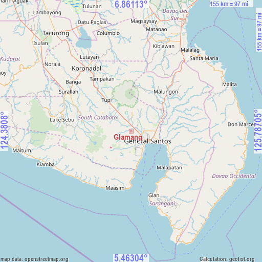
Glamang GPS coordinates[2]
6° 9' 45.18" North, 125° 5' 2.112" East
| Map corner | latitude | longitude |
|---|---|---|
| Upper-left | 6.86113°, | 124.3808° |
| Center: | 6.16255°, | 125.08392° |
| Lower-right: | 5.46304°, | 125.78705° |
| Map W x H: | 155.5×155.5 km | = 96.6×96.6mi |
| max Lat: | 20.78733° ⇑97.2% North |
| Glamang: | 6.16255° |
| min Lat: | ⇓2.8% South 4.65442° |
| min Long | Glamang | max Long |
| 117.04868° | 125.08392° | 126.58417° |
| W 89.1%⇐ | ⇒10.9% E |
Elevation
Elevation of Glamang is 228 m = 748 ft, and this is 140.1 m = 460 ft above average elevation for this country.
| Max E: |
2262 m = 7421 ft | 10% |
| Glamang | 228 m 748 ft | |
| Avg. | 87.9 m = 288 ft | |
Min E: |
-2 m = -7 ft | 90% |
See also: Philippines elevation on elevation.city.
Geographical zone
Glamang is located in North Torrid zone (between Equator and Tropic of Cancer). Distance of Equator is 685.2 km =425.8 mi to South.| Distance of | km | miles | from Glamang |
|---|---|---|---|
| North Pole | 9321.9 | 5792.4 | to North |
| Arctic Circle | 6716 | 4173.1 | to North |
| Tropic Cancer | 1920.7 | 1193.5 | to North |
| Equator | 685.2 | 425.8 | to South |


Nearby cities:
15 places around Glamang: (largest is in red/bold)
• Buayan
17.4 km =10.8 mi,  107°
107°
• Conel
12.2 km =7.6 mi,  68°
68°
• General Santos
11.2 km =7 mi,  119°
119°
• Katangawan
15.2 km =9.4 mi,  85°
85°
• Klinan
6.4 km =4 mi, 65°
• Koronadal
14.1 km =8.8 mi,  310°
310°
• Pagalungan
13.9 km =8.6 mi,  325°
325°
• Palkan
16 km =9.9 mi,  338°
338°
• Polo
11.8 km =7.3 mi,  15°
15°
• Polomolok
6.9 km =4.3 mi, 341°
• Polonoling
18.6 km =11.6 mi,  316°
316°
• Silway 7
4.4 km =2.7 mi, 68°
• Sulit
10.8 km =6.7 mi, 319°
• Tinagacan
16.6 km =10.3 mi,  75°
75°
• Upper Klinan
8.3 km =5.2 mi,  29°
29°
Sources, notices
• [Note1] Compared only with cities in Philippines existing in our database
• [Src1] Map data: © OpenStreetMap contributors (CC-BY-SA)
• [Src2] Other city data from geonames.org with taken over terms of usage.
• [Src3] Geographical zone / Annual Mean Temperature by Robert A. Rohde @ Wikipedia
