Wao geodata
Wao (Autonomous Region in Muslim Mindanao) is a seat of a third-order administrative division; located in Philippines in Asia/Manila (GMT+8) time zone. With population of 17,845 people, there are 393 cities with bigger population in this country. Compared to other cities in Philippines, 85.3% of cities are located further ↑North; 81.9% of cities are located further ←West and 99.4% of cities have lower elevation than Wao. Note1
Administrative division(s):
- Level 1: Autonomous Region in Muslim Mindanao
- Level 2: Province of Lanao del Sur
- Level 3: Wao


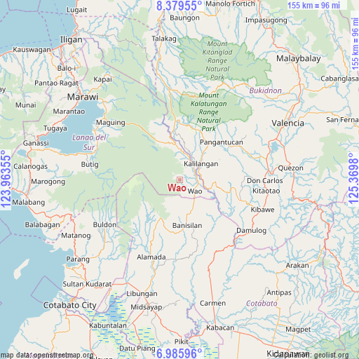
Wao GPS coordinates[2]
7° 40' 59.988" North, 124° 40' 0.012" East
| Map corner | latitude | longitude |
|---|---|---|
| Upper-left | 8.37955°, | 123.96355° |
| Center: | 7.68333°, | 124.66667° |
| Lower-right: | 6.98596°, | 125.3698° |
| Map W x H: | 155×155 km | = 96.3×96.3mi |
| max Lat: | 20.78733° ⇑85.3% North |
| Wao: | 7.68333° |
| min Lat: | ⇓14.7% South 4.65442° |
| min Long | Wao | max Long |
| 117.04868° | 124.66667° | 126.58417° |
| W 81.9%⇐ | ⇒18.1% E |
Elevation
Elevation of Wao is 1246 m = 4088 ft, and this is 1158.1 m = 3800 ft above average elevation for this country.
| Max E: |
2262 m = 7421 ft | 0.59999999999999% |
| Wao | 1246 m 4088 ft | |
| Avg. | 87.9 m = 288 ft | |
Min E: |
-2 m = -7 ft | 99.4% |
See also: Philippines elevation on elevation.city.
Geographical zone
Wao is located in North Torrid zone (between Equator and Tropic of Cancer). Distance of Equator is 854.3 km =530.8 mi to South.| Distance of | km | miles | from Wao |
|---|---|---|---|
| North Pole | 9152.8 | 5687.3 | to North |
| Arctic Circle | 6546.9 | 4068.1 | to North |
| Tropic Cancer | 1751.6 | 1088.4 | to North |
| Equator | 854.3 | 530.8 | to South |


Nearby cities:
15 places around Wao: (largest is in red/bold)
• Adtugan
25.1 km =15.6 mi,  55°
55°
• Bangahan
14.6 km =9.1 mi,  30°
30°
• Banisilan
22.3 km =13.9 mi,  163°
163°
• Bau
31 km =19.3 mi,  183°
183°
• Bumbaran
13.1 km =8.1 mi,  351°
351°
• Don Carlos
37.3 km =23.2 mi,  90°
90°
• Kadingilan
28.2 km =17.5 mi,  108°
108°
• Kalilangan
11.3 km =7 mi,  52°
52°
• Kimanuit
10.7 km =6.6 mi,  36°
36°
• Kulempang
35.5 km =22.1 mi,  239°
239°
• La Roxas
31.5 km =19.6 mi, 50°
• Malinao
14.4 km =8.9 mi, 161°
• Osias
18.9 km =11.7 mi,  119°
119°
• Pangantocan
24.3 km =15.1 mi, 41°
• Sampagar
37 km =23 mi, 120°
Sources, notices
• [Note1] Compared only with cities in Philippines existing in our database
• [Src1] Map data: © OpenStreetMap contributors (CC-BY-SA)
• [Src2] Other city data from geonames.org with taken over terms of usage.
• [Src3] Geographical zone / Annual Mean Temperature by Robert A. Rohde @ Wikipedia
