Itogon geodata
Itogon (Cordillera) is a seat of a third-order administrative division; located in Philippines in Asia/Manila (GMT+8) time zone. With population of 28,407 people, there are 290 cities with bigger population in this country. Compared to other cities in Philippines, 90.4% of cities are located further ↓South; 85.6% of cities are located further →East and 98.4% of cities have lower elevation than Itogon. Note1


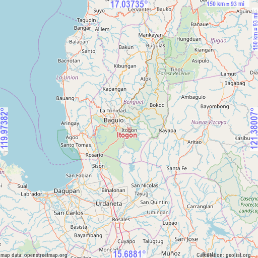
Itogon GPS coordinates[2]
16° 21' 50.004" North, 120° 40' 36.984" East
| Map corner | latitude | longitude |
|---|---|---|
| Upper-left | 17.03735°, | 119.97382° |
| Center: | 16.36389°, | 120.67694° |
| Lower-right: | 15.6881°, | 121.38007° |
| Map W x H: | 150×150 km | = 93.2×93.2mi |
| max Lat: | 20.78733° ⇑9.6% North |
| Itogon: | 16.36389° |
| min Lat: | ⇓90.4% South 4.65442° |
| min Long | Itogon | max Long |
| 117.04868° | 120.67694° | 126.58417° |
| W 14.4%⇐ | ⇒85.6% E |
Elevation
Elevation of Itogon is 808 m = 2651 ft, and this is 720.1 m = 2363 ft above average elevation for this country.
| Max E: |
2262 m = 7421 ft | 1.6% |
| Itogon | 808 m 2651 ft | |
| Avg. | 87.9 m = 288 ft | |
Min E: |
-2 m = -7 ft | 98.4% |
See also: Philippines elevation on elevation.city.
Geographical zone
Itogon is located in North Torrid zone (between Equator and Tropic of Cancer). Distance of this Northern Tropic circle is 786.4 km =488.6 mi to North.| Distance of | km | miles | from Itogon |
|---|---|---|---|
| North Pole | 8187.6 | 5087.5 | to North |
| Arctic Circle | 5581.7 | 3468.3 | to North |
| Tropic Cancer | 786.4 | 488.6 | to North |
| Equator | 1819.5 | 1130.6 | to South |


Nearby cities:
15 places around Itogon: (largest is in red/bold)
• Ambuclao
15.4 km =9.6 mi,  30°
30°
• Baguio
10.7 km =6.6 mi,  303°
303°
• Bayabas
19.6 km =12.2 mi, 299°
• Bokod
21.6 km =13.4 mi,  49°
49°
• Dalupirip
6.6 km =4.1 mi,  129°
129°
• Kayapa
22.4 km =13.9 mi,  91°
91°
• La Trinidad
13.9 km =8.6 mi,  316°
316°
• Loacan
20.7 km =12.9 mi,  356°
356°
• Nangalisan
22.6 km =14 mi,  290°
290°
• Tabaan
18.5 km =11.5 mi,  247°
247°
• Taloy
19.2 km =11.9 mi,  259°
259°
• Topdac
21.6 km =13.4 mi,  9°
9°
• Tuba
14.6 km =9.1 mi, 249°
• Tublay
21.2 km =13.2 mi,  340°
340°
• Tuding
6.4 km =4 mi, 324°
Sources, notices
• [Note1] Compared only with cities in Philippines existing in our database
• [Src1] Map data: © OpenStreetMap contributors (CC-BY-SA)
• [Src2] Other city data from geonames.org with taken over terms of usage.
• [Src3] Geographical zone / Annual Mean Temperature by Robert A. Rohde @ Wikipedia
