Panikian geodata
Panikian (Caraga) is a populated place; located in Philippines in Asia/Manila (GMT+8) time zone. With population of 2,103 people, there are 4069 cities with bigger population in this country. Compared to other cities in Philippines, 73.9% of cities are located further ↑North; 97.2% of cities are located further ←West and 62.8% of cities have higher elevation than Panikian. Note1


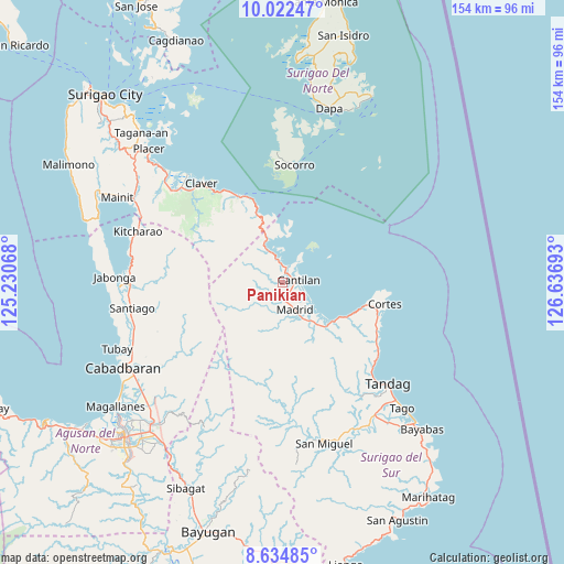
Panikian GPS coordinates[2]
9° 19' 45.66" North, 125° 56' 1.68" East
| Map corner | latitude | longitude |
|---|---|---|
| Upper-left | 10.02247°, | 125.23068° |
| Center: | 9.32935°, | 125.9338° |
| Lower-right: | 8.63485°, | 126.63693° |
| Map W x H: | 154.3×154.3 km | = 95.9×95.9mi |
| max Lat: | 20.78733° ⇑73.9% North |
| Panikian: | 9.32935° |
| min Lat: | ⇓26.1% South 4.65442° |
| min Long | Panikian | max Long |
| 117.04868° | 125.9338° | 126.58417° |
| W 97.2%⇐ | ⇒2.8% E |
Elevation
Elevation of Panikian is 15 m = 49 ft, and this is 72.9 m = 239 ft below average elevation for this country.
| Max E: |
2262 m = 7421 ft | 62.8% |
| Avg. | 87.9 m = 288 ft | |
| Panikian | 15 m = 49 ft | |
Min E: |
-2 m = -7 ft | 37.2% |
See also: Philippines elevation on elevation.city.
Geographical zone
Panikian is located in North Torrid zone (between Equator and Tropic of Cancer). Distance of Equator is 1037.3 km =644.5 mi to South.| Distance of | km | miles | from Panikian |
|---|---|---|---|
| North Pole | 8969.7 | 5573.5 | to North |
| Arctic Circle | 6363.8 | 3954.3 | to North |
| Tropic Cancer | 1568.6 | 974.7 | to North |
| Equator | 1037.3 | 644.5 | to South |


Nearby cities:
15 places around Panikian: (largest is in red/bold)
• Adlay
9.8 km =6.1 mi,  335°
335°
• Buenavista
34.5 km =21.4 mi,  133°
133°
• Burgos
28.8 km =17.9 mi,  104°
104°
• Cantilan
4.8 km =3 mi,  84°
84°
• Carmen
14.7 km =9.1 mi,  141°
141°
• Carrascal
4.9 km =3 mi,  20°
20°
• Claver
34.9 km =21.7 mi,  320°
320°
• Cortes
28.8 km =17.9 mi, 101°
• Gigaquit
39.2 km =24.4 mi, 318°
• Lanuza
17.8 km =11.1 mi, 126°
• Mabahin
30.5 km =19 mi,  121°
121°
• Madrid
8.2 km =5.1 mi,  155°
155°
• Parang
5.4 km =3.4 mi,  170°
170°
• Socorro
32.7 km =20.3 mi,  6°
6°
• Tigao
29.8 km =18.5 mi, 116°
Sources, notices
• [Note1] Compared only with cities in Philippines existing in our database
• [Src1] Map data: © OpenStreetMap contributors (CC-BY-SA)
• [Src2] Other city data from geonames.org with taken over terms of usage.
• [Src3] Geographical zone / Annual Mean Temperature by Robert A. Rohde @ Wikipedia
