Carrascal geodata
Carrascal (Caraga) is a seat of a third-order administrative division; located in Philippines in Asia/Manila (GMT+8) time zone. With population of 4,385 people, there are 1547 cities with bigger population in this country. Compared to other cities in Philippines, 73.7% of cities are located further ↑North; 97.3% of cities are located further ←West and 85.4% of cities have higher elevation than Carrascal. Note1


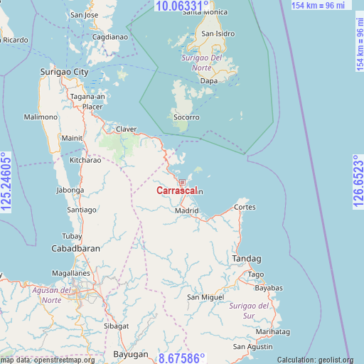
Carrascal GPS coordinates[2]
9° 22' 13.008" North, 125° 56' 57.012" East
| Map corner | latitude | longitude |
|---|---|---|
| Upper-left | 10.06331°, | 125.24605° |
| Center: | 9.37028°, | 125.94917° |
| Lower-right: | 8.67586°, | 126.6523° |
| Map W x H: | 154.3×154.3 km | = 95.9×95.9mi |
| max Lat: | 20.78733° ⇑73.7% North |
| Carrascal: | 9.37028° |
| min Lat: | ⇓26.3% South 4.65442° |
| min Long | Carrascal | max Long |
| 117.04868° | 125.94917° | 126.58417° |
| W 97.3%⇐ | ⇒2.7% E |
Elevation
Elevation of Carrascal is 8 m = 26 ft, and this is 79.9 m = 262 ft below average elevation for this country.
| Max E: |
2262 m = 7421 ft | 85.4% |
| Avg. | 87.9 m = 288 ft | |
| Carrascal | 8 m = 26 ft | |
Min E: |
-2 m = -7 ft | 14.6% |
See also: Philippines elevation on elevation.city.
Geographical zone
Carrascal is located in North Torrid zone (between Equator and Tropic of Cancer). Distance of Equator is 1041.9 km =647.4 mi to South.| Distance of | km | miles | from Carrascal |
|---|---|---|---|
| North Pole | 8965.2 | 5570.7 | to North |
| Arctic Circle | 6359.3 | 3951.5 | to North |
| Tropic Cancer | 1564 | 971.8 | to North |
| Equator | 1041.9 | 647.4 | to South |


Nearby cities:
15 places around Carrascal: (largest is in red/bold)
• Adlay
7.2 km =4.5 mi,  307°
307°
• Buenavista
36.7 km =22.8 mi,  140°
140°
• Burgos
28.7 km =17.8 mi,  113°
113°
• Cantilan
5.1 km =3.2 mi, 142°
• Carmen
17.7 km =11 mi,  154°
154°
• Claver
32.7 km =20.3 mi, 313°
• Cortes
28.4 km =17.6 mi, 110°
• Gigaquit
37.2 km =23.1 mi, 312°
• Lanuza
19.7 km =12.2 mi, 140°
• Mabahin
31.8 km =19.8 mi,  130°
130°
• Madrid
12.1 km =7.5 mi,  172°
172°
• Panikian
4.9 km =3 mi,  200°
200°
• Parang
9.9 km =6.2 mi,  184°
184°
• Socorro
28 km =17.4 mi,  3°
3°
• Tigao
30.7 km =19.1 mi, 125°
Sources, notices
• [Note1] Compared only with cities in Philippines existing in our database
• [Src1] Map data: © OpenStreetMap contributors (CC-BY-SA)
• [Src2] Other city data from geonames.org with taken over terms of usage.
• [Src3] Geographical zone / Annual Mean Temperature by Robert A. Rohde @ Wikipedia
