Cabayaoasan geodata
Cabayaoasan (Central Luzon) is a populated place; located in Philippines in Asia/Manila (GMT+8) time zone. With population of 2,798 people, there are 2793 cities with bigger population in this country. Compared to other cities in Philippines, 83.5% of cities are located further ↓South; 89.5% of cities are located further →East and 52.3% of cities have lower elevation than Cabayaoasan. Note1


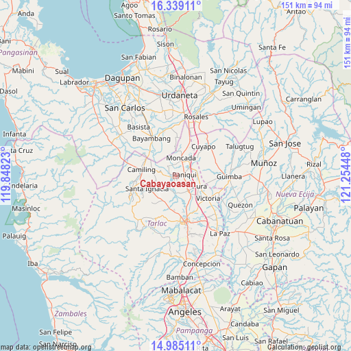
Cabayaoasan GPS coordinates[2]
15° 39' 47.628" North, 120° 33' 4.86" East
| Map corner | latitude | longitude |
|---|---|---|
| Upper-left | 16.33911°, | 119.84823° |
| Center: | 15.66323°, | 120.55135° |
| Lower-right: | 14.98511°, | 121.25448° |
| Map W x H: | 150.6×150.6 km | = 93.6×93.6mi |
| max Lat: | 20.78733° ⇑16.5% North |
| Cabayaoasan: | 15.66323° |
| min Lat: | ⇓83.5% South 4.65442° |
| min Long | Cabayaoasan | max Long |
| 117.04868° | 120.55135° | 126.58417° |
| W 10.5%⇐ | ⇒89.5% E |
Elevation
Elevation of Cabayaoasan is 25 m = 82 ft, and this is 62.9 m = 206 ft below average elevation for this country.
| Max E: |
2262 m = 7421 ft | 47.7% |
| Avg. | 87.9 m = 288 ft | |
| Cabayaoasan | 25 m = 82 ft | |
Min E: |
-2 m = -7 ft | 52.3% |
See also: Philippines elevation on elevation.city.
Geographical zone
Cabayaoasan is located in North Torrid zone (between Equator and Tropic of Cancer). Distance of this Northern Tropic circle is 864.3 km =537.1 mi to North.| Distance of | km | miles | from Cabayaoasan |
|---|---|---|---|
| North Pole | 8265.5 | 5135.9 | to North |
| Arctic Circle | 5659.6 | 3516.7 | to North |
| Tropic Cancer | 864.3 | 537.1 | to North |
| Equator | 1741.6 | 1082.2 | to South |


Nearby cities:
15 places around Cabayaoasan: (largest is in red/bold)
• Balaoang
3.9 km =2.4 mi,  270°
270°
• Balite
9.9 km =6.2 mi,  102°
102°
• Baquero Norte
5.9 km =3.7 mi,  3°
3°
• Buenlag
5.2 km =3.2 mi,  140°
140°
• Burgos
7.6 km =4.7 mi,  17°
17°
• Estacion
7.3 km =4.5 mi,  56°
56°
• Gerona
8 km =5 mi, 141°
• Mabilang
6.9 km =4.3 mi,  281°
281°
• Moncada
8.4 km =5.2 mi, 16°
• Nancamarinan
2.1 km =1.3 mi,  309°
309°
• Pance
7.9 km =4.9 mi,  69°
69°
• Paniqui
3.2 km =2 mi,  78°
78°
• Ramos
9.6 km =6 mi,  88°
88°
• Sapang
5.3 km =3.3 mi,  327°
327°
• Vargas
10.4 km =6.5 mi,  221°
221°
Sources, notices
• [Note1] Compared only with cities in Philippines existing in our database
• [Src1] Map data: © OpenStreetMap contributors (CC-BY-SA)
• [Src2] Other city data from geonames.org with taken over terms of usage.
• [Src3] Geographical zone / Annual Mean Temperature by Robert A. Rohde @ Wikipedia
