Bautista geodata
Bautista (Ilocos) is a seat of a third-order administrative division; located in Philippines in Asia/Manila (GMT+8) time zone. With population of 3,097 people, there are 2420 cities with bigger population in this country. Compared to other cities in Philippines, 84.6% of cities are located further ↓South; 90.8% of cities are located further →East and 57.6% of cities have higher elevation than Bautista. Note1


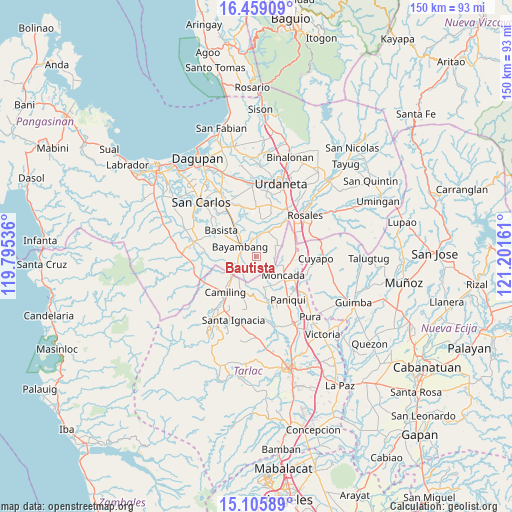
Bautista GPS coordinates[2]
15° 47' 1.032" North, 120° 29' 54.528" East
| Map corner | latitude | longitude |
|---|---|---|
| Upper-left | 16.45909°, | 119.79536° |
| Center: | 15.78362°, | 120.49848° |
| Lower-right: | 15.10589°, | 121.20161° |
| Map W x H: | 150.5×150.5 km | = 93.5×93.5mi |
| max Lat: | 20.78733° ⇑15.4% North |
| Bautista: | 15.78362° |
| min Lat: | ⇓84.6% South 4.65442° |
| min Long | Bautista | max Long |
| 117.04868° | 120.49848° | 126.58417° |
| W 9.2%⇐ | ⇒90.8% E |
Elevation
Elevation of Bautista is 18 m = 59 ft, and this is 69.9 m = 229 ft below average elevation for this country.
| Max E: |
2262 m = 7421 ft | 57.6% |
| Avg. | 87.9 m = 288 ft | |
| Bautista | 18 m = 59 ft | |
Min E: |
-2 m = -7 ft | 42.4% |
See also: Philippines elevation on elevation.city.
Geographical zone
Bautista is located in North Torrid zone (between Equator and Tropic of Cancer). Distance of this Northern Tropic circle is 850.9 km =528.7 mi to North.| Distance of | km | miles | from Bautista |
|---|---|---|---|
| North Pole | 8252.1 | 5127.6 | to North |
| Arctic Circle | 5646.2 | 3508.4 | to North |
| Tropic Cancer | 850.9 | 528.7 | to North |
| Equator | 1755 | 1090.5 | to South |


Nearby cities:
15 places around Bautista: (largest is in red/bold)
• Alcala
7.6 km =4.7 mi,  21°
21°
• Anulid
4.8 km =3 mi,  346°
346°
• Baluyot
4.2 km =2.6 mi,  288°
288°
• Bayambang
5.6 km =3.5 mi,  305°
305°
• Bical Norte
7.6 km =4.7 mi,  297°
297°
• Bilad
8.7 km =5.4 mi,  233°
233°
• Buenlag
5.3 km =3.3 mi, 15°
• Nalsian Norte
8.5 km =5.3 mi,  323°
323°
• Olea
8.8 km =5.5 mi,  356°
356°
• San Gabriel First
4.9 km =3 mi,  247°
247°
• San Pedro Apartado
9.3 km =5.8 mi,  50°
50°
• Sapang
9.4 km =5.8 mi,  162°
162°
• Tanolong
9.3 km =5.8 mi,  284°
284°
• Tococ East
9 km =5.6 mi, 300°
• Villanueva
5.4 km =3.4 mi,  72°
72°
Sources, notices
• [Note1] Compared only with cities in Philippines existing in our database
• [Src1] Map data: © OpenStreetMap contributors (CC-BY-SA)
• [Src2] Other city data from geonames.org with taken over terms of usage.
• [Src3] Geographical zone / Annual Mean Temperature by Robert A. Rohde @ Wikipedia
