Sapang geodata
Sapang (Central Luzon) is a populated place; located in Philippines in Asia/Manila (GMT+8) time zone. With population of 11,373 people, there are 542 cities with bigger population in this country. Compared to other cities in Philippines, 83.9% of cities are located further ↓South; 90.2% of cities are located further →East and 53.1% of cities have higher elevation than Sapang. Note1


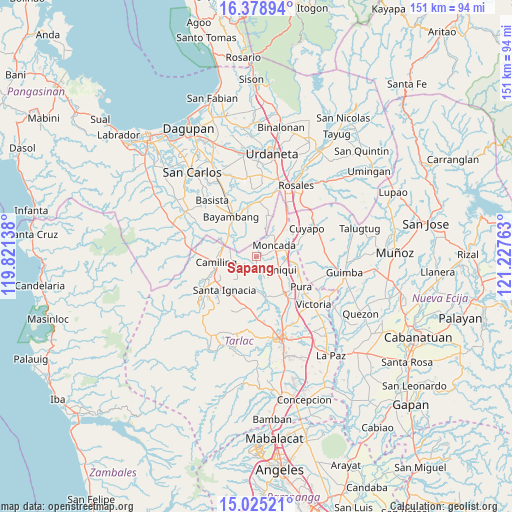
Sapang GPS coordinates[2]
15° 42' 11.52" North, 120° 31' 28.2" East
| Map corner | latitude | longitude |
|---|---|---|
| Upper-left | 16.37894°, | 119.82138° |
| Center: | 15.7032°, | 120.5245° |
| Lower-right: | 15.02521°, | 121.22763° |
| Map W x H: | 150.5×150.5 km | = 93.5×93.5mi |
| max Lat: | 20.78733° ⇑16.1% North |
| Sapang: | 15.7032° |
| min Lat: | ⇓83.9% South 4.65442° |
| min Long | Sapang | max Long |
| 117.04868° | 120.5245° | 126.58417° |
| W 9.8%⇐ | ⇒90.2% E |
Elevation
Elevation of Sapang is 21 m = 69 ft, and this is 66.9 m = 219 ft below average elevation for this country.
| Max E: |
2262 m = 7421 ft | 53.1% |
| Avg. | 87.9 m = 288 ft | |
| Sapang | 21 m = 69 ft | |
Min E: |
-2 m = -7 ft | 46.9% |
See also: Philippines elevation on elevation.city.
Geographical zone
Sapang is located in North Torrid zone (between Equator and Tropic of Cancer). Distance of this Northern Tropic circle is 859.9 km =534.3 mi to North.| Distance of | km | miles | from Sapang |
|---|---|---|---|
| North Pole | 8261 | 5133.1 | to North |
| Arctic Circle | 5655.1 | 3513.9 | to North |
| Tropic Cancer | 859.9 | 534.3 | to North |
| Equator | 1746 | 1084.9 | to South |


Nearby cities:
15 places around Sapang: (largest is in red/bold)
• Balaoang
4.6 km =2.9 mi,  193°
193°
• Baquero Norte
3.5 km =2.2 mi,  65°
65°
• Bautista
9.4 km =5.8 mi,  342°
342°
• Bilad
10.5 km =6.5 mi,  290°
290°
• Buenlag
10.4 km =6.5 mi,  143°
143°
• Burgos
5.9 km =3.7 mi,  60°
60°
• Cabayaoasan
5.3 km =3.3 mi,  147°
147°
• Estacion
9 km =5.6 mi,  92°
92°
• Mabilang
5 km =3.1 mi,  231°
231°
• Moncada
6.4 km =4 mi, 55°
• Nancamarinan
3.4 km =2.1 mi,  157°
157°
• Pance
10.4 km =6.5 mi,  99°
99°
• Paniqui
7.1 km =4.4 mi,  122°
122°
• San Gabriel First
10.1 km =6.3 mi,  314°
314°
• Sinilian First
7.1 km =4.4 mi,  261°
261°
Sources, notices
• [Note1] Compared only with cities in Philippines existing in our database
• [Src1] Map data: © OpenStreetMap contributors (CC-BY-SA)
• [Src2] Other city data from geonames.org with taken over terms of usage.
• [Src3] Geographical zone / Annual Mean Temperature by Robert A. Rohde @ Wikipedia
