Haripur geodata
Haripur (Khyber Pakhtunkhwa) is a seat of a second-order administrative division; located in Pakistan in Asia/Karachi (GMT+5) time zone. With population of 56,977 people, there are 121 cities with bigger population in this country. Compared to other cities in Pakistan, 88.9% of cities are located further ↓South; 70.9% of cities are located further ←West and 83.1% of cities have lower elevation than Haripur. Note1


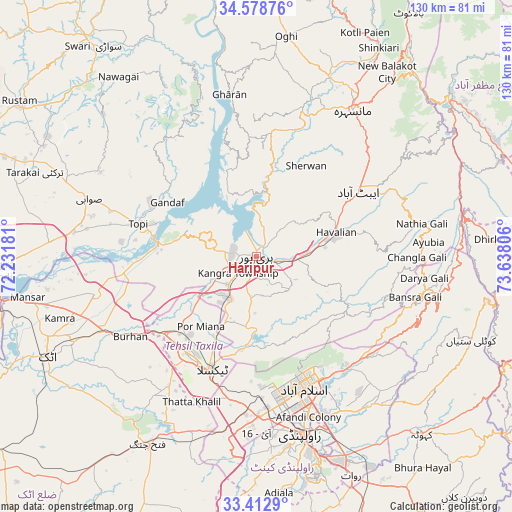
Haripur GPS coordinates[2]
33° 59' 52.188" North, 72° 56' 5.748" East
| Map corner | latitude | longitude |
|---|---|---|
| Upper-left | 34.57876°, | 72.23181° |
| Center: | 33.99783°, | 72.93493° |
| Lower-right: | 33.4129°, | 73.63806° |
| Map W x H: | 129.6×129.6 km | = 80.5×80.5mi |
| max Lat: | 36.32162° ⇑11.1% North |
| Haripur: | 33.99783° |
| min Lat: | ⇓88.9% South 24.14422° |
| min Long | Haripur | max Long |
| 61.74573° | 72.93493° | 75.63372° |
| W 70.9%⇐ | ⇒29.1% E |
Elevation
Elevation of Haripur is 537 m = 1762 ft, and this is 192 m = 630 ft above average elevation for this country.
| Max E: |
2732 m = 8963 ft | 16.9% |
| Haripur | 537 m 1762 ft | |
| Avg. | 345 m = 1132 ft | |
Min E: |
3 m = 10 ft | 83.1% |
See also: Haripur elevation on elevation.city.
Geographical zone
Haripur is located in North temperate zone (between Tropic of Cancer and the Arctic Circle). Distance of this Northern Tropic circle is 1174.3 km =729.7 mi to South.| Distance of | km | miles | from Haripur |
|---|---|---|---|
| North Pole | 6226.9 | 3869.2 | to North |
| Arctic Circle | 3621 | 2250 | to North |
| Tropic Cancer | 1174.3 | 729.7 | to South |
| Equator | 3780.2 | 2348.9 | to South |


Nearby cities:
15 places around Haripur: (largest is in red/bold)
• Abbottabad
30.4 km =18.9 mi,  57°
57°
• Amirabad
25.5 km =15.8 mi,  34°
34°
• Attock City
59 km =36.7 mi,  244°
244°
• Baffa
55.6 km =34.5 mi, 28°
• Havelian
21.6 km =13.4 mi,  73°
73°
• Hazro City
42 km =26.1 mi,  256°
256°
• Islamabad
32.3 km =20.1 mi,  161°
161°
• Khalabat
8.1 km =5 mi,  328°
328°
• Mansehra
44.1 km =27.4 mi, 33°
• Murree
43.2 km =26.8 mi,  103°
103°
• Rawalpindi
45.7 km =28.4 mi,  166°
166°
• Sanjwal
53.3 km =33.1 mi, 240°
• Swabi
45 km =28 mi,  287°
287°
• Topi
30 km =18.6 mi, 285°
• Zaida
43.7 km =27.2 mi,  279°
279°
Sources, notices
• [Note1] Compared only with cities in Pakistan existing in our database
• [Src1] Map data: © OpenStreetMap contributors (CC-BY-SA)
• [Src2] Other city data from geonames.org with taken over terms of usage.
• [Src3] Geographical zone / Annual Mean Temperature by Robert A. Rohde @ Wikipedia
