Daggar geodata
Daggar (Khyber Pakhtunkhwa) is a seat of a second-order administrative division; located in Pakistan in Asia/Karachi (GMT+5) time zone. In our database, there are 416 cities with bigger population. Compared to other cities in Pakistan, 95.3% of cities are located further ↓South; 64.8% of cities are located further ←West and 85.1% of cities have lower elevation than Daggar. Note1


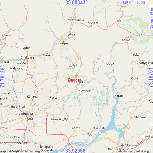
Daggar GPS coordinates[2]
34° 30' 39.816" North, 72° 29' 3.768" East
| Map corner | latitude | longitude |
|---|---|---|
| Upper-left | 35.08843°, | 71.78126° |
| Center: | 34.51106°, | 72.48438° |
| Lower-right: | 33.92966°, | 73.18751° |
| Map W x H: | 128.8×128.8 km | = 80×80mi |
| max Lat: | 36.32162° ⇑4.7% North |
| Daggar: | 34.51106° |
| min Lat: | ⇓95.3% South 24.14422° |
| min Long | Daggar | max Long |
| 61.74573° | 72.48438° | 75.63372° |
| W 64.8%⇐ | ⇒35.2% E |
Elevation
Elevation of Daggar is 719 m = 2359 ft, and this is 374 m = 1227 ft above average elevation for this country.
| Max E: |
2732 m = 8963 ft | 14.9% |
| Daggar | 719 m 2359 ft | |
| Avg. | 345 m = 1132 ft | |
Min E: |
3 m = 10 ft | 85.1% |
See also: Pakistan elevation on elevation.city.
Geographical zone
Daggar is located in North temperate zone (between Tropic of Cancer and the Arctic Circle). Distance of this Northern Tropic circle is 1231.4 km =765.2 mi to South.| Distance of | km | miles | from Daggar |
|---|---|---|---|
| North Pole | 6169.8 | 3833.7 | to North |
| Arctic Circle | 3563.9 | 2214.5 | to North |
| Tropic Cancer | 1231.4 | 765.2 | to South |
| Equator | 3837.3 | 2384.4 | to South |


Nearby cities:
15 places around Daggar: (largest is in red/bold)
• Akora
65.4 km =40.6 mi,  210°
210°
• Alpurai
47.5 km =29.5 mi,  16°
16°
• Ashanagro Koto
49.9 km =31 mi, 206°
• Bat Khela
48.4 km =30.1 mi,  284°
284°
• Battagram
52.7 km =32.7 mi,  69°
69°
• Khalabat
62.5 km =38.8 mi,  143°
143°
• Malakand
51.1 km =31.8 mi, 276°
• Mardan
53 km =32.9 mi,  228°
228°
• Mingora
31.9 km =19.8 mi,  339°
339°
• Noorabad
55.6 km =34.5 mi,  238°
238°
• Saidu Sharif
28.7 km =17.8 mi, 335°
• Shingli Bala
49.5 km =30.8 mi, 67°
• Swabi
43.5 km =27 mi,  181°
181°
• Topi
50.6 km =31.4 mi,  165°
165°
• Zaida
50.2 km =31.2 mi, 181°
Sources, notices
• [Note1] Compared only with cities in Pakistan existing in our database
• [Src1] Map data: © OpenStreetMap contributors (CC-BY-SA)
• [Src2] Other city data from geonames.org with taken over terms of usage.
• [Src3] Geographical zone / Annual Mean Temperature by Robert A. Rohde @ Wikipedia
