Hazro City geodata
Hazro City (Punjab) is a populated place; located in Pakistan in Asia/Karachi (GMT+5) time zone. With population of 26,309 people, there are 233 cities with bigger population in this country. Compared to other cities in Pakistan, 88.5% of cities are located further ↓South; 65% of cities are located further ←West and 76.5% of cities have lower elevation than Hazro City. Note1


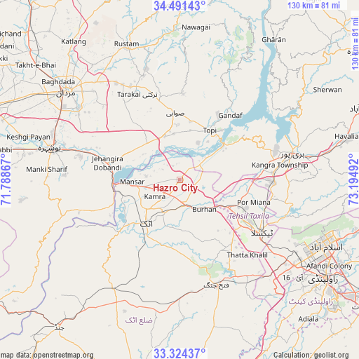
Hazro City GPS coordinates[2]
33° 54' 35.64" North, 72° 29' 30.444" East
| Map corner | latitude | longitude |
|---|---|---|
| Upper-left | 34.49143°, | 71.78867° |
| Center: | 33.9099°, | 72.49179° |
| Lower-right: | 33.32437°, | 73.19492° |
| Map W x H: | 129.8×129.8 km | = 80.7×80.7mi |
| max Lat: | 36.32162° ⇑11.5% North |
| Hazro City: | 33.9099° |
| min Lat: | ⇓88.5% South 24.14422° |
| min Long | Hazro City | max Long |
| 61.74573° | 72.49179° | 75.63372° |
| W 65%⇐ | ⇒35% E |
Elevation
Elevation of Hazro City is 320 m = 1050 ft, and this is 25 m = 82 ft below average elevation for this country.
| Max E: |
2732 m = 8963 ft | 23.5% |
| Avg. | 345 m = 1132 ft | |
| Hazro City | 320 m = 1050 ft | |
Min E: |
3 m = 10 ft | 76.5% |
See also: Pakistan elevation on elevation.city.
Geographical zone
Hazro City is located in North temperate zone (between Tropic of Cancer and the Arctic Circle). Distance of this Northern Tropic circle is 1164.5 km =723.6 mi to South.| Distance of | km | miles | from Hazro City |
|---|---|---|---|
| North Pole | 6236.6 | 3875.2 | to North |
| Arctic Circle | 3630.7 | 2256 | to North |
| Tropic Cancer | 1164.5 | 723.6 | to South |
| Equator | 3770.4 | 2342.8 | to South |


Nearby cities:
15 places around Hazro City: (largest is in red/bold)
• Akora
35.3 km =21.9 mi,  287°
287°
• Aman Garh
52.9 km =32.9 mi,  281°
281°
• Ashanagro Koto
31.6 km =19.6 mi,  314°
314°
• Attock City
20.1 km =12.5 mi,  217°
217°
• Haripur
42 km =26.1 mi,  76°
76°
• Islamabad
55.1 km =34.2 mi,  112°
112°
• Khalabat
40.3 km =25 mi,  65°
65°
• Mardan
51.8 km =32.2 mi, 308°
• Nowshera
48.5 km =30.1 mi, 284°
• Nowshera Cantonment
46.6 km =29 mi, 282°
• Risalpur Cantonment
49 km =30.4 mi, 289°
• Sanjwal
17.4 km =10.8 mi,  198°
198°
• Swabi
23.5 km =14.6 mi,  355°
355°
• Topi
21.5 km =13.4 mi,  33°
33°
• Zaida
16.8 km =10.4 mi,  352°
352°
Sources, notices
• [Note1] Compared only with cities in Pakistan existing in our database
• [Src1] Map data: © OpenStreetMap contributors (CC-BY-SA)
• [Src2] Other city data from geonames.org with taken over terms of usage.
• [Src3] Geographical zone / Annual Mean Temperature by Robert A. Rohde @ Wikipedia
