Topi geodata
Topi (Khyber Pakhtunkhwa) is a populated place; located in Pakistan in Asia/Karachi (GMT+5) time zone. With population of 36,340 people, there are 172 cities with bigger population in this country. Compared to other cities in Pakistan, 91.4% of cities are located further ↓South; 66.1% of cities are located further ←West and 78.8% of cities have lower elevation than Topi. Note1


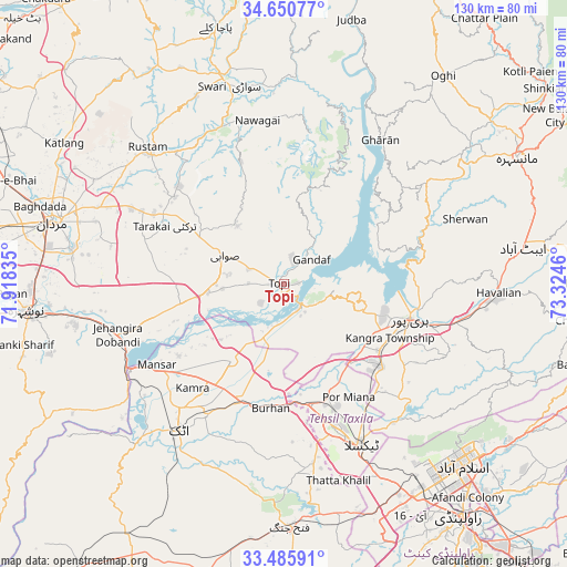
Topi GPS coordinates[2]
34° 4' 13.224" North, 72° 37' 17.292" East
| Map corner | latitude | longitude |
|---|---|---|
| Upper-left | 34.65077°, | 71.91835° |
| Center: | 34.07034°, | 72.62147° |
| Lower-right: | 33.48591°, | 73.3246° |
| Map W x H: | 129.5×129.5 km | = 80.5×80.5mi |
| max Lat: | 36.32162° ⇑8.6% North |
| Topi: | 34.07034° |
| min Lat: | ⇓91.4% South 24.14422° |
| min Long | Topi | max Long |
| 61.74573° | 72.62147° | 75.63372° |
| W 66.1%⇐ | ⇒33.9% E |
Elevation
Elevation of Topi is 348 m = 1142 ft, and this is 3 m = 10 ft above average elevation for this country.
| Max E: |
2732 m = 8963 ft | 21.2% |
| Topi | 348 m 1142 ft | |
| Avg. | 345 m = 1132 ft | |
Min E: |
3 m = 10 ft | 78.8% |
See also: Pakistan elevation on elevation.city.
Geographical zone
Topi is located in North temperate zone (between Tropic of Cancer and the Arctic Circle). Distance of this Northern Tropic circle is 1182.3 km =734.6 mi to South.| Distance of | km | miles | from Topi |
|---|---|---|---|
| North Pole | 6218.8 | 3864.2 | to North |
| Arctic Circle | 3612.9 | 2245 | to North |
| Tropic Cancer | 1182.3 | 734.6 | to South |
| Equator | 3788.3 | 2353.9 | to South |


Nearby cities:
15 places around Topi: (largest is in red/bold)
• Abbottabad
55 km =34.2 mi,  81°
81°
• Akora
46.3 km =28.8 mi,  260°
260°
• Amirabad
45.1 km =28 mi,  73°
73°
• Ashanagro Koto
34.9 km =21.7 mi,  276°
276°
• Attock City
41.5 km =25.8 mi,  215°
215°
• Daggar
50.6 km =31.4 mi,  345°
345°
• Haripur
30 km =18.6 mi,  105°
105°
• Havelian
49.6 km =30.8 mi,  92°
92°
• Hazro City
21.5 km =13.4 mi,  213°
213°
• Islamabad
55 km =34.2 mi,  134°
134°
• Khalabat
24.7 km =15.3 mi, 92°
• Mardan
54.5 km =33.9 mi,  285°
285°
• Sanjwal
38.5 km =23.9 mi, 206°
• Swabi
15 km =9.3 mi, 291°
• Zaida
14.3 km =8.9 mi,  265°
265°
Sources, notices
• [Note1] Compared only with cities in Pakistan existing in our database
• [Src1] Map data: © OpenStreetMap contributors (CC-BY-SA)
• [Src2] Other city data from geonames.org with taken over terms of usage.
• [Src3] Geographical zone / Annual Mean Temperature by Robert A. Rohde @ Wikipedia
