Sanjwal geodata
Sanjwal (Punjab) is a populated place; located in Pakistan in Asia/Karachi (GMT+5) time zone. With population of 10,657 people, there are 348 cities with bigger population in this country. Compared to other cities in Pakistan, 87.1% of cities are located further ↓South; 63.4% of cities are located further ←West and 79.2% of cities have lower elevation than Sanjwal. Note1


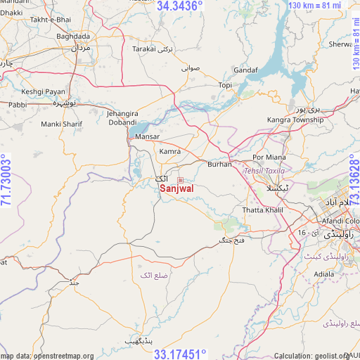
Sanjwal GPS coordinates[2]
33° 45' 39.78" North, 72° 25' 59.34" East
| Map corner | latitude | longitude |
|---|---|---|
| Upper-left | 34.3436°, | 71.73003° |
| Center: | 33.76105°, | 72.43315° |
| Lower-right: | 33.17451°, | 73.13628° |
| Map W x H: | 130×130 km | = 80.8×80.8mi |
| max Lat: | 36.32162° ⇑12.9% North |
| Sanjwal: | 33.76105° |
| min Lat: | ⇓87.1% South 24.14422° |
| min Long | Sanjwal | max Long |
| 61.74573° | 72.43315° | 75.63372° |
| W 63.4%⇐ | ⇒36.6% E |
Elevation
Elevation of Sanjwal is 357 m = 1171 ft, and this is 12 m = 39 ft above average elevation for this country.
| Max E: |
2732 m = 8963 ft | 20.8% |
| Sanjwal | 357 m 1171 ft | |
| Avg. | 345 m = 1132 ft | |
Min E: |
3 m = 10 ft | 79.2% |
See also: Pakistan elevation on elevation.city.
Geographical zone
Sanjwal is located in North temperate zone (between Tropic of Cancer and the Arctic Circle). Distance of this Northern Tropic circle is 1148 km =713.3 mi to South.| Distance of | km | miles | from Sanjwal |
|---|---|---|---|
| North Pole | 6253.2 | 3885.6 | to North |
| Arctic Circle | 3647.3 | 2266.3 | to North |
| Tropic Cancer | 1148 | 713.3 | to South |
| Equator | 3753.9 | 2332.6 | to South |


Nearby cities:
15 places around Sanjwal: (largest is in red/bold)
• Akora
39.1 km =24.3 mi,  313°
313°
• Aman Garh
53.9 km =33.5 mi,  300°
300°
• Ashanagro Koto
42.3 km =26.3 mi,  335°
335°
• Attock City
6.8 km =4.2 mi,  275°
275°
• Cherat Cantonement
50.4 km =31.3 mi, 277°
• Haripur
53.3 km =33.1 mi,  60°
60°
• Hazro City
17.4 km =10.8 mi,  18°
18°
• Jand
52.9 km =32.9 mi,  226°
226°
• Khalabat
53.7 km =33.4 mi,  51°
51°
• Nowshera
50.4 km =31.3 mi, 304°
• Nowshera Cantonment
48 km =29.8 mi, 303°
• Risalpur Cantonment
52.5 km =32.6 mi, 309°
• Swabi
40.1 km =24.9 mi,  4°
4°
• Topi
38.5 km =23.9 mi,  26°
26°
• Zaida
33.3 km =20.7 mi,  5°
5°
Sources, notices
• [Note1] Compared only with cities in Pakistan existing in our database
• [Src1] Map data: © OpenStreetMap contributors (CC-BY-SA)
• [Src2] Other city data from geonames.org with taken over terms of usage.
• [Src3] Geographical zone / Annual Mean Temperature by Robert A. Rohde @ Wikipedia
