Umarkot geodata
Umarkot (Sindh) is a seat of a second-order administrative division; located in Pakistan in Asia/Karachi (GMT+5) time zone. With population of 42,074 people, there are 149 cities with bigger population in this country. Compared to other cities in Pakistan, 92.1% of cities are located further ↑North; 63.7% of cities are located further →East and 92.8% of cities have higher elevation than Umarkot. Note1


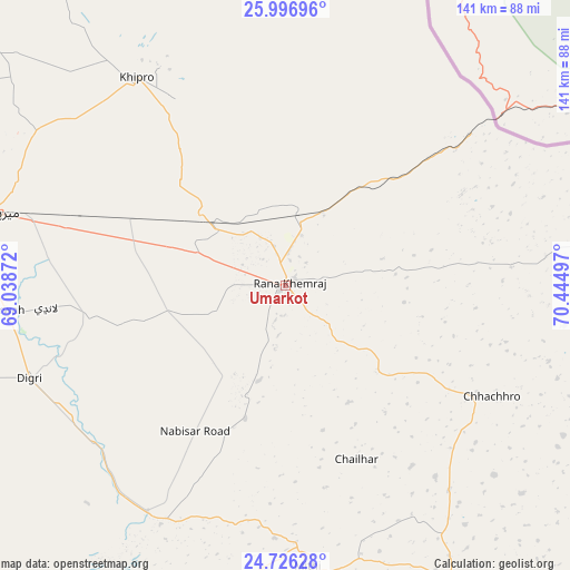
Umarkot GPS coordinates[2]
25° 21' 47.844" North, 69° 44' 30.624" East
| Map corner | latitude | longitude |
|---|---|---|
| Upper-left | 25.99696°, | 69.03872° |
| Center: | 25.36329°, | 69.74184° |
| Lower-right: | 24.72628°, | 70.44497° |
| Map W x H: | 141.3×141.3 km | = 87.8×87.8mi |
| max Lat: | 36.32162° ⇑92.1% North |
| Umarkot: | 25.36329° |
| min Lat: | ⇓7.9% South 24.14422° |
| min Long | Umarkot | max Long |
| 61.74573° | 69.74184° | 75.63372° |
| W 36.3%⇐ | ⇒63.7% E |
Elevation
Elevation of Umarkot is 20 m = 66 ft, and this is 325 m = 1066 ft below average elevation for this country.
| Max E: |
2732 m = 8963 ft | 92.8% |
| Avg. | 345 m = 1132 ft | |
| Umarkot | 20 m = 66 ft | |
Min E: |
3 m = 10 ft | 7.2% |
See also: Umarkot elevation on elevation.city.
Geographical zone
Umarkot is located in North temperate zone (between Tropic of Cancer and the Arctic Circle). Distance of this Northern Tropic circle is 214.2 km =133.1 mi to South.| Distance of | km | miles | from Umarkot |
|---|---|---|---|
| North Pole | 7186.9 | 4465.7 | to North |
| Arctic Circle | 4581 | 2846.5 | to North |
| Tropic Cancer | 214.2 | 133.1 | to South |
| Equator | 2820.1 | 1752.3 | to South |


Nearby cities:
15 places around Umarkot: (largest is in red/bold)
• Chamber
93.8 km =58.3 mi,  265°
265°
• Chhor
17.1 km =10.6 mi,  14°
14°
• Dhoro Naro
23.3 km =14.5 mi,  312°
312°
• Digri
67.5 km =41.9 mi,  250°
250°
• Islamkot
86 km =53.4 mi,  149°
149°
• Kunri
27.1 km =16.8 mi,  220°
220°
• Mirpur Khas
75.5 km =46.9 mi,  284°
284°
• Mirwah Gorchani
69.8 km =43.4 mi, 265°
• Mithi
69.9 km =43.4 mi,  175°
175°
• Nabisar
34.4 km =21.4 mi,  196°
196°
• Naukot
65.8 km =40.9 mi,  211°
211°
• Pithoro
40.1 km =24.9 mi,  294°
294°
• Rajo Khanani
98.8 km =61.4 mi,  244°
244°
• Samaro
35.9 km =22.3 mi,  255°
255°
• Tando Mitha Khan
88.7 km =55.1 mi,  322°
322°
Sources, notices
• [Note1] Compared only with cities in Pakistan existing in our database
• [Src1] Map data: © OpenStreetMap contributors (CC-BY-SA)
• [Src2] Other city data from geonames.org with taken over terms of usage.
• [Src3] Geographical zone / Annual Mean Temperature by Robert A. Rohde @ Wikipedia
