Islamkot geodata
Islamkot (Sindh) is a populated place; located in Pakistan in Asia/Karachi (GMT+5) time zone. With population of 12,426 people, there are 336 cities with bigger population in this country. Compared to other cities in Pakistan, 98.4% of cities are located further ↑North; 61.9% of cities are located further →East and 76.7% of cities have higher elevation than Islamkot. Note1


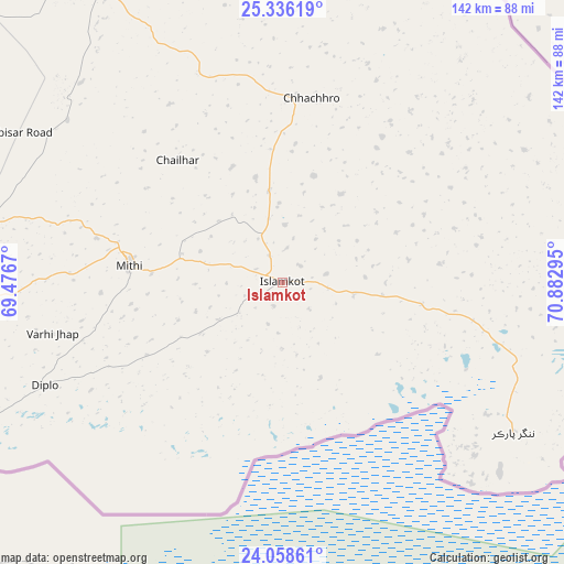
Islamkot GPS coordinates[2]
24° 41' 56.544" North, 70° 10' 47.352" East
| Map corner | latitude | longitude |
|---|---|---|
| Upper-left | 25.33619°, | 69.4767° |
| Center: | 24.69904°, | 70.17982° |
| Lower-right: | 24.05861°, | 70.88295° |
| Map W x H: | 142.1×142.1 km | = 88.3×88.3mi |
| max Lat: | 36.32162° ⇑98.4% North |
| Islamkot: | 24.69904° |
| min Lat: | ⇓1.6% South 24.14422° |
| min Long | Islamkot | max Long |
| 61.74573° | 70.17982° | 75.63372° |
| W 38.1%⇐ | ⇒61.9% E |
Elevation
Elevation of Islamkot is 59 m = 194 ft, and this is 286 m = 938 ft below average elevation for this country.
| Max E: |
2732 m = 8963 ft | 76.7% |
| Avg. | 345 m = 1132 ft | |
| Islamkot | 59 m = 194 ft | |
Min E: |
3 m = 10 ft | 23.3% |
See also: Pakistan elevation on elevation.city.
Geographical zone
Islamkot is located in North temperate zone (between Tropic of Cancer and the Arctic Circle). Distance of this Northern Tropic circle is 140.4 km =87.2 mi to South.| Distance of | km | miles | from Islamkot |
|---|---|---|---|
| North Pole | 7260.8 | 4511.7 | to North |
| Arctic Circle | 4654.9 | 2892.4 | to North |
| Tropic Cancer | 140.4 | 87.2 | to South |
| Equator | 2746.3 | 1706.5 | to South |


Nearby cities:
15 places around Islamkot: (largest is in red/bold)
• Badin
135.8 km =84.4 mi,  267°
267°
• Chhor
98.8 km =61.4 mi,  336°
336°
• Dhoro Naro
108.6 km =67.5 mi,  325°
325°
• Digri
119.2 km =74.1 mi,  295°
295°
• Diplo
65.8 km =40.9 mi,  246°
246°
• Kadhan
123.2 km =76.6 mi,  258°
258°
• Kunri
81.7 km =50.8 mi,  310°
310°
• Mirwah Gorchani
132.5 km =82.3 mi, 300°
• Mithi
38.9 km =24.2 mi,  276°
276°
• Nabisar
67.8 km =42.1 mi, 307°
• Naukot
80.5 km =50 mi, 282°
• Pithoro
121.1 km =75.2 mi,  318°
318°
• Samaro
102.1 km =63.4 mi, 309°
• Tando Bago
123 km =76.4 mi, 274°
• Umarkot
86 km =53.4 mi, 329°
Sources, notices
• [Note1] Compared only with cities in Pakistan existing in our database
• [Src1] Map data: © OpenStreetMap contributors (CC-BY-SA)
• [Src2] Other city data from geonames.org with taken over terms of usage.
• [Src3] Geographical zone / Annual Mean Temperature by Robert A. Rohde @ Wikipedia
