Nasirabad geodata
Nasirabad (Sindh) is a populated place; located in Pakistan in Asia/Karachi (GMT+5) time zone. With population of 27,809 people, there are 222 cities with bigger population in this country. Compared to other cities in Pakistan, 78.3% of cities are located further ↑North; 89.6% of cities are located further →East and 83.5% of cities have higher elevation than Nasirabad. Note1


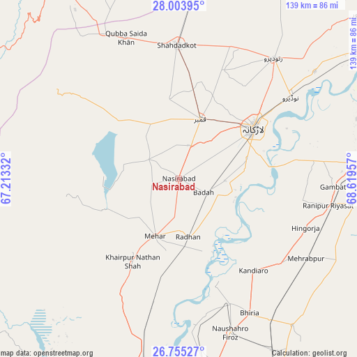
Nasirabad GPS coordinates[2]
27° 22' 52.932" North, 67° 54' 59.184" East
| Map corner | latitude | longitude |
|---|---|---|
| Upper-left | 28.00395°, | 67.21332° |
| Center: | 27.38137°, | 67.91644° |
| Lower-right: | 26.75527°, | 68.61957° |
| Map W x H: | 138.8×138.8 km | = 86.2×86.2mi |
| max Lat: | 36.32162° ⇑78.3% North |
| Nasirabad: | 27.38137° |
| min Lat: | ⇓21.7% South 24.14422° |
| min Long | Nasirabad | max Long |
| 61.74573° | 67.91644° | 75.63372° |
| W 10.4%⇐ | ⇒89.6% E |
Elevation
Elevation of Nasirabad is 49 m = 161 ft, and this is 296 m = 971 ft below average elevation for this country.
| Max E: |
2732 m = 8963 ft | 83.5% |
| Avg. | 345 m = 1132 ft | |
| Nasirabad | 49 m = 161 ft | |
Min E: |
3 m = 10 ft | 16.5% |
See also: Pakistan elevation on elevation.city.
Geographical zone
Nasirabad is located in North temperate zone (between Tropic of Cancer and the Arctic Circle). Distance of this Northern Tropic circle is 438.6 km =272.5 mi to South.| Distance of | km | miles | from Nasirabad |
|---|---|---|---|
| North Pole | 6962.5 | 4326.3 | to North |
| Arctic Circle | 4356.7 | 2707.1 | to North |
| Tropic Cancer | 438.6 | 272.5 | to South |
| Equator | 3044.5 | 1891.8 | to South |


Nearby cities:
15 places around Nasirabad: (largest is in red/bold)
• Dokri
17.9 km =11.1 mi,  92°
92°
• Goth Garelo
16.8 km =10.4 mi,  69°
69°
• Goth Radhan
20.7 km =12.9 mi,  169°
169°
• Kambar
24.4 km =15.2 mi,  19°
19°
• Kandiaro
46.1 km =28.6 mi,  140°
140°
• Khairpur Nathan Shah
37 km =23 mi,  209°
209°
• Larkana
35.2 km =21.9 mi,  55°
55°
• Mehar
24.3 km =15.1 mi,  202°
202°
• Miro Khan
45.5 km =28.3 mi, 22°
• New Bādāh
12.2 km =7.6 mi,  111°
111°
• Shahdad Kot
51.8 km =32.2 mi,  358°
358°
• Sobhodero
48.2 km =30 mi,  100°
100°
• Sīta Road
39.3 km =24.4 mi,  189°
189°
• Tharu Shah
52.7 km =32.7 mi,  157°
157°
• Warah
14 km =8.7 mi,  302°
302°
Sources, notices
• [Note1] Compared only with cities in Pakistan existing in our database
• [Src1] Map data: © OpenStreetMap contributors (CC-BY-SA)
• [Src2] Other city data from geonames.org with taken over terms of usage.
• [Src3] Geographical zone / Annual Mean Temperature by Robert A. Rohde @ Wikipedia
