Timargara geodata
Timargara (Khyber Pakhtunkhwa) is a seat of a second-order administrative division; located in Pakistan in Asia/Karachi (GMT+5) time zone. In our database, there are 416 cities with bigger population. Compared to other cities in Pakistan, 97.1% of cities are located further ↓South; 54.4% of cities are located further ←West and 85.8% of cities have lower elevation than Timargara. Note1


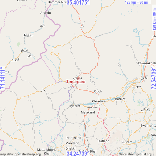
Timargara GPS coordinates[2]
34° 49' 35.724" North, 71° 50' 39.228" East
| Map corner | latitude | longitude |
|---|---|---|
| Upper-left | 35.40175°, | 71.14111° |
| Center: | 34.82659°, | 71.84423° |
| Lower-right: | 34.24739°, | 72.54736° |
| Map W x H: | 128.4×128.4 km | = 79.8×79.8mi |
| max Lat: | 36.32162° ⇑2.9% North |
| Timargara: | 34.82659° |
| min Lat: | ⇓97.1% South 24.14422° |
| min Long | Timargara | max Long |
| 61.74573° | 71.84423° | 75.63372° |
| W 54.4%⇐ | ⇒45.6% E |
Elevation
Elevation of Timargara is 778 m = 2552 ft, and this is 433 m = 1421 ft above average elevation for this country.
| Max E: |
2732 m = 8963 ft | 14.2% |
| Timargara | 778 m 2552 ft | |
| Avg. | 345 m = 1132 ft | |
Min E: |
3 m = 10 ft | 85.8% |
See also: Pakistan elevation on elevation.city.
Geographical zone
Timargara is located in North temperate zone (between Tropic of Cancer and the Arctic Circle). Distance of this Northern Tropic circle is 1266.4 km =786.9 mi to South.| Distance of | km | miles | from Timargara |
|---|---|---|---|
| North Pole | 6134.7 | 3811.9 | to North |
| Arctic Circle | 3528.8 | 2192.7 | to North |
| Tropic Cancer | 1266.4 | 786.9 | to South |
| Equator | 3872.4 | 2406.2 | to South |


Nearby cities:
15 places around Timargara: (largest is in red/bold)
• Alpurai
72.7 km =45.2 mi,  81°
81°
• Bat Khela
26 km =16.2 mi,  153°
153°
• Charsadda
76 km =47.2 mi,  187°
187°
• Daggar
68.2 km =42.4 mi,  120°
120°
• Kakad Wari Dir Upper
28.3 km =17.6 mi,  47°
47°
• Malakand
30.1 km =18.7 mi,  164°
164°
• Mardan
72.4 km =45 mi, 164°
• Mingora
47.6 km =29.6 mi,  96°
96°
• Noorabad
64.9 km =40.3 mi,  170°
170°
• Saidu Sharif
47.5 km =29.5 mi, 100°
• Shabqadar
72.9 km =45.3 mi,  201°
201°
• Tangi
61 km =37.9 mi, 196°
• Thal
81.1 km =50.4 mi,  26°
26°
• Upper Dir
42.4 km =26.3 mi,  4°
4°
• Utmanzai
71.4 km =44.4 mi, 186°
Sources, notices
• [Note1] Compared only with cities in Pakistan existing in our database
• [Src1] Map data: © OpenStreetMap contributors (CC-BY-SA)
• [Src2] Other city data from geonames.org with taken over terms of usage.
• [Src3] Geographical zone / Annual Mean Temperature by Robert A. Rohde @ Wikipedia
