Baddomalhi geodata
Baddomalhi (Punjab) is a populated place; located in Pakistan in Asia/Karachi (GMT+5) time zone. With population of 18,435 people, there are 281 cities with bigger population in this country. Compared to other cities in Pakistan, 66.4% of cities are located further ↓South; 98.2% of cities are located further ←West and 66.1% of cities have lower elevation than Baddomalhi. Note1


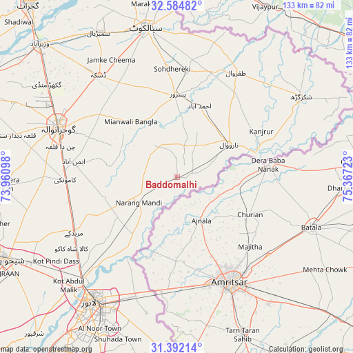
Baddomalhi GPS coordinates[2]
31° 59' 25.512" North, 74° 39' 50.76" East
| Map corner | latitude | longitude |
|---|---|---|
| Upper-left | 32.58482°, | 73.96098° |
| Center: | 31.99042°, | 74.6641° |
| Lower-right: | 31.39214°, | 75.36723° |
| Map W x H: | 132.6×132.6 km | = 82.4×82.4mi |
| max Lat: | 36.32162° ⇑33.6% North |
| Baddomalhi: | 31.99042° |
| min Lat: | ⇓66.4% South 24.14422° |
| min Long | Baddomalhi | max Long |
| 61.74573° | 74.6641° | 75.63372° |
| W 98.2%⇐ | ⇒1.8% E |
Elevation
Elevation of Baddomalhi is 228 m = 748 ft, and this is 117 m = 384 ft below average elevation for this country.
| Max E: |
2732 m = 8963 ft | 33.9% |
| Avg. | 345 m = 1132 ft | |
| Baddomalhi | 228 m = 748 ft | |
Min E: |
3 m = 10 ft | 66.1% |
See also: Pakistan elevation on elevation.city.
Geographical zone
Baddomalhi is located in North temperate zone (between Tropic of Cancer and the Arctic Circle). Distance of this Northern Tropic circle is 951.1 km =591 mi to South.| Distance of | km | miles | from Baddomalhi |
|---|---|---|---|
| North Pole | 6450.1 | 4007.9 | to North |
| Arctic Circle | 3844.2 | 2388.7 | to North |
| Tropic Cancer | 951.1 | 591 | to South |
| Equator | 3557 | 2210.2 | to South |


Nearby cities:
15 places around Baddomalhi: (largest is in red/bold)
• Chawinda
39.5 km =24.5 mi,  5°
5°
• Daska Kalan
47.4 km =29.5 mi,  321°
321°
• Eminabad
38.5 km =23.9 mi,  278°
278°
• Fazilpur
43.1 km =26.8 mi,  61°
61°
• Gujranwala
48.6 km =30.2 mi,  292°
292°
• Kalaswala
23.4 km =14.5 mi,  356°
356°
• Kamoke
41.6 km =25.8 mi,  267°
267°
• Kot Ghulam Muhammad
39.7 km =24.7 mi,  343°
343°
• Kot Rajkour
47 km =29.2 mi, 355°
• Ladhewala Waraich
54.9 km =34.1 mi, 289°
• Muridke
43.7 km =27.2 mi,  241°
241°
• Narang Mandi
17 km =10.6 mi, 235°
• Narowal
23.3 km =14.5 mi, 57°
• Pasrur
30.3 km =18.8 mi, 359°
• Zafarwal
45.2 km =28.1 mi,  29°
29°
Sources, notices
• [Note1] Compared only with cities in Pakistan existing in our database
• [Src1] Map data: © OpenStreetMap contributors (CC-BY-SA)
• [Src2] Other city data from geonames.org with taken over terms of usage.
• [Src3] Geographical zone / Annual Mean Temperature by Robert A. Rohde @ Wikipedia
