Mingora geodata
Mingora (Khyber Pakhtunkhwa) is a populated place; located in Pakistan in Asia/Karachi (GMT+5) time zone. With population of 279,914 people, there are 26 cities with bigger population in this country. Compared to other cities in Pakistan, 96.8% of cities are located further ↓South; 62.5% of cities are located further ←West and 88% of cities have lower elevation than Mingora. Note1


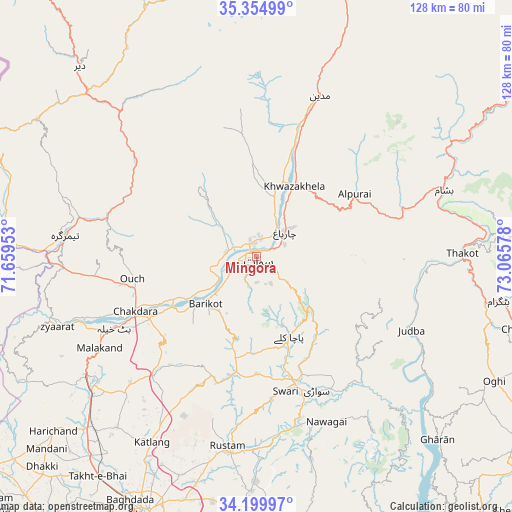
Mingora GPS coordinates[2]
34° 46' 46.2" North, 72° 21' 45.54" East
| Map corner | latitude | longitude |
|---|---|---|
| Upper-left | 35.35499°, | 71.65953° |
| Center: | 34.7795°, | 72.36265° |
| Lower-right: | 34.19997°, | 73.06578° |
| Map W x H: | 128.4×128.4 km | = 79.8×79.8mi |
| max Lat: | 36.32162° ⇑3.2% North |
| Mingora: | 34.7795° |
| min Lat: | ⇓96.8% South 24.14422° |
| min Long | Mingora | max Long |
| 61.74573° | 72.36265° | 75.63372° |
| W 62.5%⇐ | ⇒37.5% E |
Elevation
Elevation of Mingora is 939 m = 3081 ft, and this is 594 m = 1949 ft above average elevation for this country.
| Max E: |
2732 m = 8963 ft | 12% |
| Mingora | 939 m 3081 ft | |
| Avg. | 345 m = 1132 ft | |
Min E: |
3 m = 10 ft | 88% |
See also: Mingora elevation on elevation.city.
Geographical zone
Mingora is located in North temperate zone (between Tropic of Cancer and the Arctic Circle). Distance of this Northern Tropic circle is 1261.2 km =783.7 mi to South.| Distance of | km | miles | from Mingora |
|---|---|---|---|
| North Pole | 6139.9 | 3815.2 | to North |
| Arctic Circle | 3534.1 | 2196 | to North |
| Tropic Cancer | 1261.2 | 783.7 | to South |
| Equator | 3867.1 | 2402.9 | to South |


Nearby cities:
15 places around Mingora: (largest is in red/bold)
• Alpurai
29.2 km =18.1 mi,  57°
57°
• Ashanagro Koto
75.5 km =46.9 mi,  188°
188°
• Bat Khela
39.9 km =24.8 mi,  243°
243°
• Battagram
61.4 km =38.2 mi,  100°
100°
• Daggar
31.9 km =19.8 mi,  159°
159°
• Kakad Wari Dir Upper
35.9 km =22.3 mi,  312°
312°
• Malakand
46.1 km =28.6 mi, 238°
• Mardan
70.7 km =43.9 mi,  203°
203°
• Noorabad
69 km =42.9 mi,  211°
211°
• Saidu Sharif
3.7 km =2.3 mi, 189°
• Shingli Bala
58 km =36 mi, 101°
• Swabi
74 km =46 mi,  172°
172°
• Thal
78.5 km =48.8 mi,  352°
352°
• Timargara
47.6 km =29.6 mi,  276°
276°
• Upper Dir
65 km =40.4 mi,  317°
317°
Sources, notices
• [Note1] Compared only with cities in Pakistan existing in our database
• [Src1] Map data: © OpenStreetMap contributors (CC-BY-SA)
• [Src2] Other city data from geonames.org with taken over terms of usage.
• [Src3] Geographical zone / Annual Mean Temperature by Robert A. Rohde @ Wikipedia
