Bhawana geodata
Bhawana (Punjab) is a populated place; located in Pakistan in Asia/Karachi (GMT+5) time zone. With population of 16,218 people, there are 300 cities with bigger population in this country. Compared to other cities in Pakistan, 59.8% of cities are located further ↓South; 67% of cities are located further ←West and 52.1% of cities have higher elevation than Bhawana. Note1


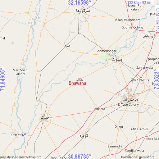
Bhawana GPS coordinates[2]
31° 34' 7.824" North, 72° 38' 57.012" East
| Map corner | latitude | longitude |
|---|---|---|
| Upper-left | 32.16598°, | 71.94605° |
| Center: | 31.56884°, | 72.64917° |
| Lower-right: | 30.96785°, | 73.3523° |
| Map W x H: | 133.2×133.2 km | = 82.8×82.8mi |
| max Lat: | 36.32162° ⇑40.2% North |
| Bhawana: | 31.56884° |
| min Lat: | ⇓59.8% South 24.14422° |
| min Long | Bhawana | max Long |
| 61.74573° | 72.64917° | 75.63372° |
| W 67%⇐ | ⇒33% E |
Elevation
Elevation of Bhawana is 172 m = 564 ft, and this is 173 m = 568 ft below average elevation for this country.
| Max E: |
2732 m = 8963 ft | 52.1% |
| Avg. | 345 m = 1132 ft | |
| Bhawana | 172 m = 564 ft | |
Min E: |
3 m = 10 ft | 47.9% |
See also: Pakistan elevation on elevation.city.
Geographical zone
Bhawana is located in North temperate zone (between Tropic of Cancer and the Arctic Circle). Distance of this Northern Tropic circle is 904.2 km =561.8 mi to South.| Distance of | km | miles | from Bhawana |
|---|---|---|---|
| North Pole | 6496.9 | 4037 | to North |
| Arctic Circle | 3891 | 2417.8 | to North |
| Tropic Cancer | 904.2 | 561.8 | to South |
| Equator | 3510.1 | 2181.1 | to South |


Nearby cities:
15 places around Bhawana: (largest is in red/bold)
• Chak Jhumra
50.6 km =31.4 mi,  90°
90°
• Chenab Nagar
32.5 km =20.2 mi,  50°
50°
• Chiniot
35.5 km =22.1 mi,  61°
61°
• Dijkot
51.1 km =31.8 mi,  139°
139°
• Faisalabad
45.1 km =28 mi,  112°
112°
• Faruka
41.8 km =26 mi,  327°
327°
• Gojra
46.8 km =29.1 mi,  176°
176°
• Jahanian Shah
43.9 km =27.3 mi,  306°
306°
• Jhang City
42.4 km =26.3 mi,  226°
226°
• Jhang Sadr
45.8 km =28.5 mi,  223°
223°
• Lalian
31.9 km =19.8 mi,  26°
26°
• Mangla
44 km =27.3 mi,  324°
324°
• Sahiwal
54.1 km =33.6 mi, 326°
• Sargodha
57.5 km =35.7 mi,  2°
2°
• Sillanwali
30.3 km =18.8 mi,  340°
340°
Sources, notices
• [Note1] Compared only with cities in Pakistan existing in our database
• [Src1] Map data: © OpenStreetMap contributors (CC-BY-SA)
• [Src2] Other city data from geonames.org with taken over terms of usage.
• [Src3] Geographical zone / Annual Mean Temperature by Robert A. Rohde @ Wikipedia
