Chiniot geodata
Chiniot (Punjab) is a seat of a second-order administrative division; located in Pakistan in Asia/Karachi (GMT+5) time zone. With population of 201,781 people, there are 32 cities with bigger population in this country. Compared to other cities in Pakistan, 61.2% of cities are located further ↓South; 71.6% of cities are located further ←West and 54.2% of cities have lower elevation than Chiniot. Note1


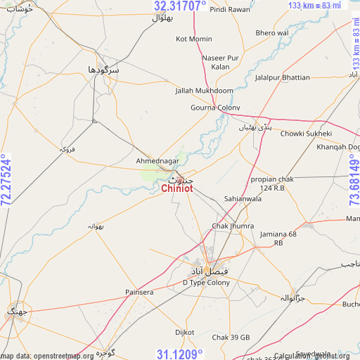
Chiniot GPS coordinates[2]
31° 43' 15.276" North, 72° 58' 42.096" East
| Map corner | latitude | longitude |
|---|---|---|
| Upper-left | 32.31707°, | 72.27524° |
| Center: | 31.72091°, | 72.97836° |
| Lower-right: | 31.1209°, | 73.68149° |
| Map W x H: | 133×133 km | = 82.6×82.6mi |
| max Lat: | 36.32162° ⇑38.8% North |
| Chiniot: | 31.72091° |
| min Lat: | ⇓61.2% South 24.14422° |
| min Long | Chiniot | max Long |
| 61.74573° | 72.97836° | 75.63372° |
| W 71.6%⇐ | ⇒28.4% E |
Elevation
Elevation of Chiniot is 189 m = 620 ft, and this is 156 m = 512 ft below average elevation for this country.
| Max E: |
2732 m = 8963 ft | 45.8% |
| Avg. | 345 m = 1132 ft | |
| Chiniot | 189 m = 620 ft | |
Min E: |
3 m = 10 ft | 54.2% |
See also: Chiniot elevation on elevation.city.
Geographical zone
Chiniot is located in North temperate zone (between Tropic of Cancer and the Arctic Circle). Distance of this Northern Tropic circle is 921.1 km =572.3 mi to South.| Distance of | km | miles | from Chiniot |
|---|---|---|---|
| North Pole | 6480 | 4026.5 | to North |
| Arctic Circle | 3874.1 | 2407.3 | to North |
| Tropic Cancer | 921.1 | 572.3 | to South |
| Equator | 3527 | 2191.6 | to South |


Nearby cities:
15 places around Chiniot: (largest is in red/bold)
• Bhawana
35.5 km =22.1 mi,  241°
241°
• Chak Jhumra
25.8 km =16 mi,  131°
131°
• Chenab Nagar
7.2 km =4.5 mi,  302°
302°
• Dijkot
56 km =34.8 mi,  178°
178°
• Faisalabad
35.6 km =22.1 mi,  162°
162°
• Khurrianwala
36.8 km =22.9 mi, 131°
• Kot Mumin
52.2 km =32.4 mi,  5°
5°
• Lalian
20.3 km =12.6 mi, 304°
• Liliani
53.8 km =33.4 mi,  357°
357°
• Pindi Bhattian
34.2 km =21.3 mi,  54°
54°
• Sangla Hill
38.3 km =23.8 mi,  90°
90°
• Sargodha
49.7 km =30.9 mi,  324°
324°
• Shahkot
50.8 km =31.6 mi,  109°
109°
• Sillanwali
43 km =26.7 mi,  285°
285°
• Sukheke Mandi
52.6 km =32.7 mi,  72°
72°
Sources, notices
• [Note1] Compared only with cities in Pakistan existing in our database
• [Src1] Map data: © OpenStreetMap contributors (CC-BY-SA)
• [Src2] Other city data from geonames.org with taken over terms of usage.
• [Src3] Geographical zone / Annual Mean Temperature by Robert A. Rohde @ Wikipedia
