Islamabad geodata
Islamabad is a capital of a political entity; located in Pakistan in Asia/Karachi (GMT+5) time zone. With population of 601,600 people, there are 13 cities with bigger population in this country. Compared to other cities in Pakistan, 86.7% of cities are located further ↓South; 73.6% of cities are located further ←West and 83.5% of cities have lower elevation than Islamabad. Note1


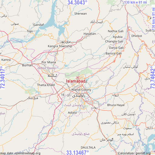
Islamabad GPS coordinates[2]
33° 43' 17.328" North, 73° 2' 35.844" East
| Map corner | latitude | longitude |
|---|---|---|
| Upper-left | 34.3043°, | 72.34017° |
| Center: | 33.72148°, | 73.04329° |
| Lower-right: | 33.13467°, | 73.74642° |
| Map W x H: | 130.1×130.1 km | = 80.8×80.8mi |
| max Lat: | 36.32162° ⇑13.3% North |
| Islamabad: | 33.72148° |
| min Lat: | ⇓86.7% South 24.14422° |
| min Long | Islamabad | max Long |
| 61.74573° | 73.04329° | 75.63372° |
| W 73.6%⇐ | ⇒26.4% E |
Elevation
Elevation of Islamabad is 579 m = 1900 ft, and this is 234 m = 768 ft above average elevation for this country.
| Max E: |
2732 m = 8963 ft | 16.5% |
| Islamabad | 579 m 1900 ft | |
| Avg. | 345 m = 1132 ft | |
Min E: |
3 m = 10 ft | 83.5% |
See also: Islamabad elevation on elevation.city.
Geographical zone
Islamabad is located in North temperate zone (between Tropic of Cancer and the Arctic Circle). Distance of this Northern Tropic circle is 1143.6 km =710.6 mi to South.| Distance of | km | miles | from Islamabad |
|---|---|---|---|
| North Pole | 6257.6 | 3888.3 | to North |
| Arctic Circle | 3651.7 | 2269.1 | to North |
| Tropic Cancer | 1143.6 | 710.6 | to South |
| Equator | 3749.5 | 2329.8 | to South |


Nearby cities:
15 places around Islamabad: (largest is in red/bold)
• Abbottabad
49.7 km =30.9 mi,  18°
18°
• Amirabad
52 km =32.3 mi,  4°
4°
• Daultala
59.5 km =37 mi,  171°
171°
• Gujar Khan
57.3 km =35.6 mi,  155°
155°
• Haripur
32.3 km =20.1 mi,  341°
341°
• Havelian
38.5 km =23.9 mi, 16°
• Hazro City
55.1 km =34.2 mi,  292°
292°
• Kahuta
35 km =21.7 mi,  114°
114°
• Kamra
43.5 km =27 mi,  86°
86°
• Khalabat
40.2 km =25 mi, 339°
• Murree
38.2 km =23.7 mi,  57°
57°
• Nazir Town
61.6 km =38.3 mi,  138°
138°
• Rawalpindi
13.8 km =8.6 mi,  178°
178°
• Sanjwal
56.6 km =35.2 mi,  274°
274°
• Topi
55 km =34.2 mi,  314°
314°
Sources, notices
• [Note1] Compared only with cities in Pakistan existing in our database
• [Src1] Map data: © OpenStreetMap contributors (CC-BY-SA)
• [Src2] Other city data from geonames.org with taken over terms of usage.
• [Src3] Geographical zone / Annual Mean Temperature by Robert A. Rohde @ Wikipedia
