Harunabad geodata
Harunabad (Punjab) is a populated place; located in Pakistan in Asia/Karachi (GMT+5) time zone. With population of 72,432 people, there are 94 cities with bigger population in this country. Compared to other cities in Pakistan, 62.3% of cities are located further ↑North; 75.6% of cities are located further ←West and 55.3% of cities have higher elevation than Harunabad. Note1


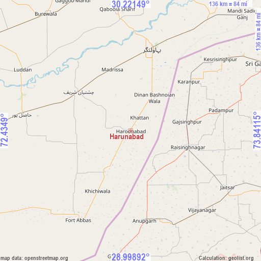
Harunabad GPS coordinates[2]
29° 36' 43.416" North, 73° 8' 16.872" East
| Map corner | latitude | longitude |
|---|---|---|
| Upper-left | 30.22149°, | 72.4349° |
| Center: | 29.61206°, | 73.13802° |
| Lower-right: | 28.99892°, | 73.84115° |
| Map W x H: | 135.9×135.9 km | = 84.4×84.4mi |
| max Lat: | 36.32162° ⇑62.3% North |
| Harunabad: | 29.61206° |
| min Lat: | ⇓37.7% South 24.14422° |
| min Long | Harunabad | max Long |
| 61.74573° | 73.13802° | 75.63372° |
| W 75.6%⇐ | ⇒24.4% E |
Elevation
Elevation of Harunabad is 162 m = 531 ft, and this is 183 m = 600 ft below average elevation for this country.
| Max E: |
2732 m = 8963 ft | 55.3% |
| Avg. | 345 m = 1132 ft | |
| Harunabad | 162 m = 531 ft | |
Min E: |
3 m = 10 ft | 44.7% |
See also: Harunabad elevation on elevation.city.
Geographical zone
Harunabad is located in North temperate zone (between Tropic of Cancer and the Arctic Circle). Distance of this Northern Tropic circle is 686.6 km =426.6 mi to South.| Distance of | km | miles | from Harunabad |
|---|---|---|---|
| North Pole | 6714.5 | 4172.2 | to North |
| Arctic Circle | 4108.6 | 2553 | to North |
| Tropic Cancer | 686.6 | 426.6 | to South |
| Equator | 3292.6 | 2045.9 | to South |


Nearby cities:
15 places around Harunabad: (largest is in red/bold)
• Arifwala
75.8 km =47.1 mi,  354°
354°
• Bahawalnagar
44.4 km =27.6 mi,  14°
14°
• Būrewāla
77.6 km =48.2 mi,  322°
322°
• Chak One Hundred Twenty Nine Left
91.3 km =56.7 mi, 354°
• Chishtian
34 km =21.1 mi,  307°
307°
• Dinan Bashnoian Wala
21.1 km =13.1 mi,  35°
35°
• Dunga Bunga
18.4 km =11.4 mi,  33°
33°
• Faqirwali
18.9 km =11.7 mi,  211°
211°
• Fort Abbas
54 km =33.6 mi, 210°
• Hasilpur
57.9 km =36 mi,  278°
278°
• Khairpur Tamewah
87.1 km =54.1 mi,  267°
267°
• Mailsi
95.4 km =59.3 mi, 282°
• Minchianabad
74 km =46 mi, 34°
• Pakpattan
84.8 km =52.7 mi,  16°
16°
• Vihari
89.5 km =55.6 mi,  302°
302°
Sources, notices
• [Note1] Compared only with cities in Pakistan existing in our database
• [Src1] Map data: © OpenStreetMap contributors (CC-BY-SA)
• [Src2] Other city data from geonames.org with taken over terms of usage.
• [Src3] Geographical zone / Annual Mean Temperature by Robert A. Rohde @ Wikipedia
