Minchianabad geodata
Minchianabad (Punjab) is a populated place; located in Pakistan in Asia/Karachi (GMT+5) time zone. With population of 29,253 people, there are 213 cities with bigger population in this country. Compared to other cities in Pakistan, 57.6% of cities are located further ↑North; 82.4% of cities are located further ←West and 53.7% of cities have higher elevation than Minchianabad. Note1


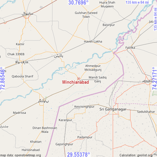
Minchianabad GPS coordinates[2]
30° 9' 48.816" North, 73° 34' 6.888" East
| Map corner | latitude | longitude |
|---|---|---|
| Upper-left | 30.7696°, | 72.86546° |
| Center: | 30.16356°, | 73.56858° |
| Lower-right: | 29.55378°, | 74.27171° |
| Map W x H: | 135.2×135.2 km | = 84×84mi |
| max Lat: | 36.32162° ⇑57.6% North |
| Minchianabad: | 30.16356° |
| min Lat: | ⇓42.4% South 24.14422° |
| min Long | Minchianabad | max Long |
| 61.74573° | 73.56858° | 75.63372° |
| W 82.4%⇐ | ⇒17.6% E |
Elevation
Elevation of Minchianabad is 168 m = 551 ft, and this is 177 m = 581 ft below average elevation for this country.
| Max E: |
2732 m = 8963 ft | 53.7% |
| Avg. | 345 m = 1132 ft | |
| Minchianabad | 168 m = 551 ft | |
Min E: |
3 m = 10 ft | 46.3% |
See also: Pakistan elevation on elevation.city.
Geographical zone
Minchianabad is located in North temperate zone (between Tropic of Cancer and the Arctic Circle). Distance of this Northern Tropic circle is 748 km =464.8 mi to South.| Distance of | km | miles | from Minchianabad |
|---|---|---|---|
| North Pole | 6653.2 | 4134.1 | to North |
| Arctic Circle | 4047.3 | 2514.9 | to North |
| Tropic Cancer | 748 | 464.8 | to South |
| Equator | 3353.9 | 2084 | to South |


Nearby cities:
15 places around Minchianabad: (largest is in red/bold)
• Arifwala
50.3 km =31.3 mi,  286°
286°
• Bahawalnagar
35.5 km =22.1 mi,  238°
238°
• Bahawalnagar
46.3 km =28.8 mi,  338°
338°
• Basirpur
52.8 km =32.8 mi,  29°
29°
• Chak One Hundred Twenty Nine Left
58.3 km =36.2 mi,  300°
300°
• Dinan Bashnoian Wala
53 km =32.9 mi,  213°
213°
• Dipalpur
56.9 km =35.4 mi,  8°
8°
• Dunga Bunga
55.7 km =34.6 mi, 214°
• Harunabad
74 km =46 mi, 214°
• Haveli Lakha
34.1 km =21.2 mi,  20°
20°
• Hujra Shah Muqim
68.8 km =42.8 mi, 20°
• Okara
72.8 km =45.2 mi,  351°
351°
• Pakpattan
26.4 km =16.4 mi,  319°
319°
• Renala Khurd
79.6 km =49.5 mi,  2°
2°
• Sahiwal
71.6 km =44.5 mi, 321°
Sources, notices
• [Note1] Compared only with cities in Pakistan existing in our database
• [Src1] Map data: © OpenStreetMap contributors (CC-BY-SA)
• [Src2] Other city data from geonames.org with taken over terms of usage.
• [Src3] Geographical zone / Annual Mean Temperature by Robert A. Rohde @ Wikipedia
