Būrewāla geodata
Būrewāla (Punjab) is a populated place; located in Pakistan in Asia/Karachi (GMT+5) time zone. With population of 183,915 people, there are 36 cities with bigger population in this country. Compared to other cities in Pakistan, 57.3% of cities are located further ↑North; 67.3% of cities are located further ←West and 59.8% of cities have higher elevation than Būrewāla. Note1


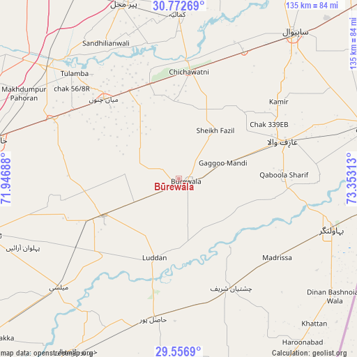
Būrewāla GPS coordinates[2]
30° 10' 0.012" North, 72° 39' 0" East
| Map corner | latitude | longitude |
|---|---|---|
| Upper-left | 30.77269°, | 71.94688° |
| Center: | 30.16667°, | 72.65° |
| Lower-right: | 29.5569°, | 73.35313° |
| Map W x H: | 135.2×135.2 km | = 84×84mi |
| max Lat: | 36.32162° ⇑57.3% North |
| Būrewāla: | 30.16667° |
| min Lat: | ⇓42.7% South 24.14422° |
| min Long | Būrewāla | max Long |
| 61.74573° | 72.65° | 75.63372° |
| W 67.3%⇐ | ⇒32.7% E |
Elevation
Elevation of Būrewāla is 146 m = 479 ft, and this is 199 m = 653 ft below average elevation for this country.
| Max E: |
2732 m = 8963 ft | 59.8% |
| Avg. | 345 m = 1132 ft | |
| Būrewāla | 146 m = 479 ft | |
Min E: |
3 m = 10 ft | 40.2% |
See also: Būrewāla elevation on elevation.city.
Geographical zone
Būrewāla is located in North temperate zone (between Tropic of Cancer and the Arctic Circle). Distance of this Northern Tropic circle is 748.3 km =465 mi to South.| Distance of | km | miles | from Būrewāla |
|---|---|---|---|
| North Pole | 6652.8 | 4133.9 | to North |
| Arctic Circle | 4047 | 2514.7 | to North |
| Tropic Cancer | 748.3 | 465 | to South |
| Equator | 3354.2 | 2084.2 | to South |


Nearby cities:
15 places around Būrewāla: (largest is in red/bold)
• Arifwala
42.2 km =26.2 mi,  70°
70°
• Bahawalnagar
60.9 km =37.8 mi,  107°
107°
• Chak One Hundred Twenty Nine Left
47.9 km =29.8 mi,  52°
52°
• Chak Thirty-one -Eleven Left
29 km =18 mi,  9°
9°
• Chichawatni
40.6 km =25.2 mi, 5°
• Chishtian
45.7 km =28.4 mi,  154°
154°
• Hasilpur
53.7 km =33.4 mi,  190°
190°
• Kamalia
62.3 km =38.7 mi,  359°
359°
• Khanewal
70.6 km =43.9 mi,  282°
282°
• Mailsi
61.3 km =38.1 mi,  228°
228°
• Mian Channun
41.5 km =25.8 mi,  317°
317°
• Pir Mahal
69.8 km =43.4 mi,  342°
342°
• Sahiwal
70.4 km =43.7 mi,  37°
37°
• Talamba
56.1 km =34.9 mi, 315°
• Vihari
31.4 km =19.5 mi,  244°
244°
Sources, notices
• [Note1] Compared only with cities in Pakistan existing in our database
• [Src1] Map data: © OpenStreetMap contributors (CC-BY-SA)
• [Src2] Other city data from geonames.org with taken over terms of usage.
• [Src3] Geographical zone / Annual Mean Temperature by Robert A. Rohde @ Wikipedia
