Pakpattan geodata
Pakpattan (Punjab) is a seat of a second-order administrative division; located in Pakistan in Asia/Karachi (GMT+5) time zone. With population of 126,706 people, there are 51 cities with bigger population in this country. Compared to other cities in Pakistan, 55.8% of cities are located further ↑North; 79.7% of cities are located further ←West and 53.7% of cities have lower elevation than Pakpattan. Note1


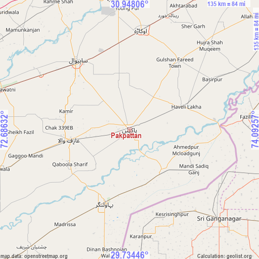
Pakpattan GPS coordinates[2]
30° 20' 35.304" North, 73° 23' 21.984" East
| Map corner | latitude | longitude |
|---|---|---|
| Upper-left | 30.94806°, | 72.68632° |
| Center: | 30.34314°, | 73.38944° |
| Lower-right: | 29.73446°, | 74.09257° |
| Map W x H: | 134.9×134.9 km | = 83.8×83.8mi |
| max Lat: | 36.32162° ⇑55.8% North |
| Pakpattan: | 30.34314° |
| min Lat: | ⇓44.2% South 24.14422° |
| min Long | Pakpattan | max Long |
| 61.74573° | 73.38944° | 75.63372° |
| W 79.7%⇐ | ⇒20.3% E |
Elevation
Elevation of Pakpattan is 188 m = 617 ft, and this is 157 m = 515 ft below average elevation for this country.
| Max E: |
2732 m = 8963 ft | 46.3% |
| Avg. | 345 m = 1132 ft | |
| Pakpattan | 188 m = 617 ft | |
Min E: |
3 m = 10 ft | 53.7% |
See also: Pakpattan elevation on elevation.city.
Geographical zone
Pakpattan is located in North temperate zone (between Tropic of Cancer and the Arctic Circle). Distance of this Northern Tropic circle is 767.9 km =477.2 mi to South.| Distance of | km | miles | from Pakpattan |
|---|---|---|---|
| North Pole | 6633.2 | 4121.7 | to North |
| Arctic Circle | 4027.3 | 2502.4 | to North |
| Tropic Cancer | 767.9 | 477.2 | to South |
| Equator | 3373.8 | 2096.4 | to South |


Nearby cities:
15 places around Pakpattan: (largest is in red/bold)
• Arifwala
31.6 km =19.6 mi,  259°
259°
• Bahawalnagar
23.1 km =14.4 mi,  0°
0°
• Bahawalnagar
40.5 km =25.2 mi,  198°
198°
• Basirpur
50.4 km =31.3 mi,  58°
58°
• Chak Azam Sahu
57.1 km =35.5 mi,  322°
322°
• Chak One Hundred Twenty Nine Left
34.4 km =21.4 mi,  286°
286°
• Dinan Bashnoian Wala
65.3 km =40.6 mi,  190°
190°
• Dipalpur
44.2 km =27.5 mi,  34°
34°
• Haveli Lakha
31.5 km =19.6 mi,  67°
67°
• Hujra Shah Muqim
60.7 km =37.7 mi,  43°
43°
• Minchianabad
26.4 km =16.4 mi,  139°
139°
• Mustafābād
61.9 km =38.5 mi,  9°
9°
• Okara
52.3 km =32.5 mi, 6°
• Renala Khurd
62.8 km =39 mi,  18°
18°
• Sahiwal
45.2 km =28.1 mi, 322°
Sources, notices
• [Note1] Compared only with cities in Pakistan existing in our database
• [Src1] Map data: © OpenStreetMap contributors (CC-BY-SA)
• [Src2] Other city data from geonames.org with taken over terms of usage.
• [Src3] Geographical zone / Annual Mean Temperature by Robert A. Rohde @ Wikipedia
