Vihari geodata
Vihari (Punjab) is a seat of a second-order administrative division; located in Pakistan in Asia/Karachi (GMT+5) time zone. With population of 112,840 people, there are 60 cities with bigger population in this country. Compared to other cities in Pakistan, 58.7% of cities are located further ↑North; 61.6% of cities are located further ←West and 62.1% of cities have higher elevation than Vihari. Note1


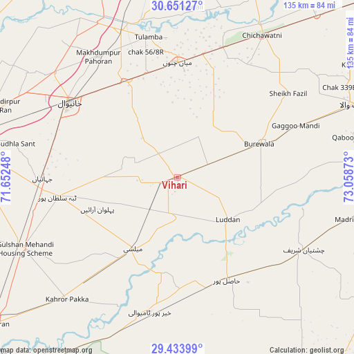
Vihari GPS coordinates[2]
30° 2' 40.2" North, 72° 21' 20.16" East
| Map corner | latitude | longitude |
|---|---|---|
| Upper-left | 30.65127°, | 71.65248° |
| Center: | 30.0445°, | 72.3556° |
| Lower-right: | 29.43399°, | 73.05873° |
| Map W x H: | 135.3×135.4 km | = 84.1×84.1mi |
| max Lat: | 36.32162° ⇑58.7% North |
| Vihari: | 30.0445° |
| min Lat: | ⇓41.3% South 24.14422° |
| min Long | Vihari | max Long |
| 61.74573° | 72.3556° | 75.63372° |
| W 61.6%⇐ | ⇒38.4% E |
Elevation
Elevation of Vihari is 140 m = 459 ft, and this is 205 m = 673 ft below average elevation for this country.
| Max E: |
2732 m = 8963 ft | 62.1% |
| Avg. | 345 m = 1132 ft | |
| Vihari | 140 m = 459 ft | |
Min E: |
3 m = 10 ft | 37.9% |
See also: Vihari elevation on elevation.city.
Geographical zone
Vihari is located in North temperate zone (between Tropic of Cancer and the Arctic Circle). Distance of this Northern Tropic circle is 734.7 km =456.5 mi to South.| Distance of | km | miles | from Vihari |
|---|---|---|---|
| North Pole | 6666.4 | 4142.3 | to North |
| Arctic Circle | 4060.5 | 2523.1 | to North |
| Tropic Cancer | 734.7 | 456.5 | to South |
| Equator | 3340.6 | 2075.8 | to South |


Nearby cities:
15 places around Vihari: (largest is in red/bold)
• Būrewāla
31.4 km =19.5 mi,  64°
64°
• Chak Thirty-one -Eleven Left
53.5 km =33.2 mi,  37°
37°
• Chichawatni
62.9 km =39.1 mi,  30°
30°
• Chishtian
55.7 km =34.6 mi,  119°
119°
• Dunyapur
64.8 km =40.3 mi,  245°
245°
• Hasilpur
43.2 km =26.8 mi,  154°
154°
• Kabirwala
62 km =38.5 mi,  310°
310°
• Kahror Pakka
63.2 km =39.3 mi,  222°
222°
• Khairpur Tamewah
52.7 km =32.7 mi,  192°
192°
• Khanewal
49.8 km =30.9 mi, 305°
• Mailsi
32.2 km =20 mi,  212°
212°
• Mian Channun
44.1 km =27.4 mi,  0°
0°
• Qadirpur Ran
71.3 km =44.3 mi,  292°
292°
• Sarai Sidhu
71.5 km =44.4 mi,  328°
328°
• Talamba
54.8 km =34.1 mi,  348°
348°
Sources, notices
• [Note1] Compared only with cities in Pakistan existing in our database
• [Src1] Map data: © OpenStreetMap contributors (CC-BY-SA)
• [Src2] Other city data from geonames.org with taken over terms of usage.
• [Src3] Geographical zone / Annual Mean Temperature by Robert A. Rohde @ Wikipedia
