Chak One Hundred Twenty Nine Left geodata
Chak One Hundred Twenty Nine Left (Punjab) is a populated place; located in Pakistan in Asia/Karachi (GMT+5) time zone. With population of 24,053 people, there are 247 cities with bigger population in this country. Compared to other cities in Pakistan, 54.6% of cities are located further ↑North; 74% of cities are located further ←West and 55.3% of cities have higher elevation than Chak One Hundred Twenty Nine Left. Note1
Current local time in Chak One Hundred Twenty Nine Left:
12:02 AM, SaturdayDifference from your time zone: hours


Chak One Hundred Twenty Nine Left GPS coordinates[2]
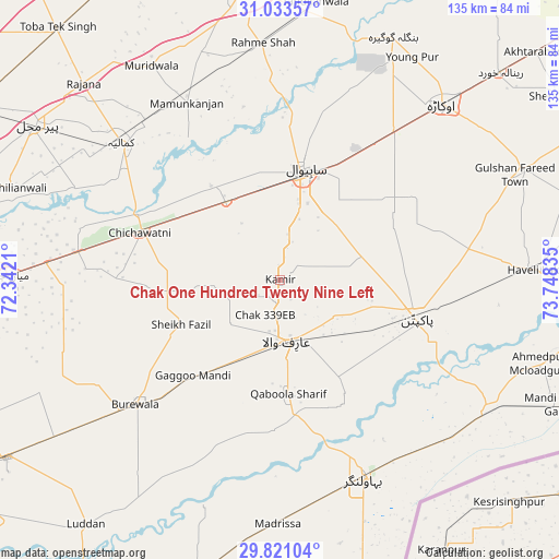
30° 25' 45.084" North, 73° 2' 42.792" East
| Map corner | latitude | longitude |
|---|---|---|
| Upper-left | 31.03357°, | 72.3421° |
| Center: | 30.42919°, | 73.04522° |
| Lower-right: | 29.82104°, | 73.74835° |
| Map W x H: | 134.8×134.8 km | = 83.8×83.8mi |
| max Lat: | 36.32162° ⇑54.6% North |
| Chak One Hundred Twenty Nine Left: | 30.42919° |
| min Lat: | ⇓45.4% South 24.14422° |
| min Long | Chak One Hundre | max Long |
| 61.74573° | 73.04522° | 75.63372° |
| W 74%⇐ | ⇒26% E |
Elevation
Elevation of Chak One Hundred Twenty Nine Left is 162 m = 531 ft, and this is 183 m = 600 ft below average elevation for this country.
| Max E: |
2732 m = 8963 ft | 55.3% |
| Avg. | 345 m = 1132 ft | |
| Chak One Hundred Twenty Nine Left | 162 m = 531 ft | |
Min E: |
3 m = 10 ft | 44.7% |
See also: Pakistan elevation on elevation.city.
Geographical zone
Chak One Hundred Twenty Nine Left is located in North temperate zone (between Tropic of Cancer and the Arctic Circle). Distance of this Northern Tropic circle is 777.5 km =483.1 mi to South.| Distance of | km | miles | from Chak One Hundred Twenty Nine Left |
|---|---|---|---|
| North Pole | 6623.7 | 4115.8 | to North |
| Arctic Circle | 4017.8 | 2496.5 | to North |
| Tropic Cancer | 777.5 | 483.1 | to South |
| Equator | 3383.4 | 2102.3 | to South |


Nearby cities:
15 places around Chak One Hundred Twenty Nine Left: (largest is in red/bold)
• Arifwala
15.5 km =9.6 mi,  172°
172°
• Bahawalnagar
35.8 km =22.2 mi,  67°
67°
• Bahawalnagar
51.9 km =32.2 mi,  157°
157°
• Būrewāla
47.9 km =29.8 mi,  232°
232°
• Chak Azam Sahu
35.9 km =22.3 mi,  357°
357°
• Chak Thirty-one -Eleven Left
33.4 km =20.8 mi,  268°
268°
• Chichawatni
35.7 km =22.2 mi,  288°
288°
• Dipalpur
64.1 km =39.8 mi, 65°
• Haveli Lakha
62.2 km =38.6 mi,  87°
87°
• Kamalia
50.6 km =31.4 mi,  310°
310°
• Mamu Kanjan
50.4 km =31.3 mi,  332°
332°
• Minchianabad
58.3 km =36.2 mi,  120°
120°
• Okara
57.5 km =35.7 mi,  42°
42°
• Pakpattan
34.4 km =21.4 mi,  106°
106°
• Sahiwal
26.9 km =16.7 mi,  11°
11°
Sources, notices
• [Note1] Compared only with cities in Pakistan existing in our database
• [Src1] Map data: © OpenStreetMap contributors (CC-BY-SA)
• [Src2] Other city data from geonames.org with taken over terms of usage.
• [Src3] Geographical zone / Annual Mean Temperature by Robert A. Rohde @ Wikipedia
