Larkana geodata
Larkana (Sindh) is a seat of a second-order administrative division; located in Pakistan in Asia/Karachi (GMT+5) time zone. With population of 364,033 people, there are 18 cities with bigger population in this country. Compared to other cities in Pakistan, 77.4% of cities are located further ↑North; 84.7% of cities are located further →East and 81% of cities have higher elevation than Larkana. Note1


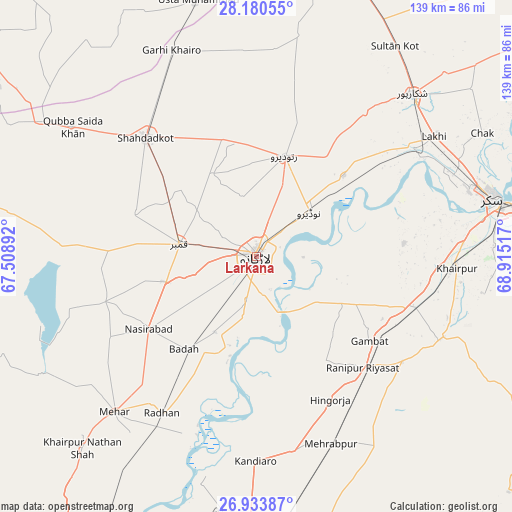
Larkana GPS coordinates[2]
27° 33' 32.328" North, 68° 12' 43.344" East
| Map corner | latitude | longitude |
|---|---|---|
| Upper-left | 28.18055°, | 67.50892° |
| Center: | 27.55898°, | 68.21204° |
| Lower-right: | 26.93387°, | 68.91517° |
| Map W x H: | 138.6×138.6 km | = 86.1×86.1mi |
| max Lat: | 36.32162° ⇑77.4% North |
| Larkana: | 27.55898° |
| min Lat: | ⇓22.6% South 24.14422° |
| min Long | Larkana | max Long |
| 61.74573° | 68.21204° | 75.63372° |
| W 15.3%⇐ | ⇒84.7% E |
Elevation
Elevation of Larkana is 52 m = 171 ft, and this is 293 m = 961 ft below average elevation for this country.
| Max E: |
2732 m = 8963 ft | 81% |
| Avg. | 345 m = 1132 ft | |
| Larkana | 52 m = 171 ft | |
Min E: |
3 m = 10 ft | 19% |
See also: Larkana elevation on elevation.city.
Geographical zone
Larkana is located in North temperate zone (between Tropic of Cancer and the Arctic Circle). Distance of this Northern Tropic circle is 458.4 km =284.8 mi to South.| Distance of | km | miles | from Larkana |
|---|---|---|---|
| North Pole | 6942.8 | 4314.1 | to North |
| Arctic Circle | 4336.9 | 2694.8 | to North |
| Tropic Cancer | 458.4 | 284.8 | to South |
| Equator | 3064.3 | 1904.1 | to South |


Nearby cities:
15 places around Larkana: (largest is in red/bold)
• Dokri
23.5 km =14.6 mi,  208°
208°
• Gambat
38.3 km =23.8 mi,  127°
127°
• Goth Garelo
19.2 km =11.9 mi,  224°
224°
• Hingorja
43.6 km =27.1 mi,  152°
152°
• Kambar
21.1 km =13.1 mi,  278°
278°
• Madeji
32 km =19.9 mi,  47°
47°
• Miro Khan
25.3 km =15.7 mi,  332°
332°
• Nasirabad
35.2 km =21.9 mi,  235°
235°
• Naudero
18.9 km =11.7 mi, 50°
• New Bādāh
30 km =18.6 mi, 216°
• Pir Jo Goth
40.2 km =25 mi,  84°
84°
• Ranipur
41.9 km =26 mi,  136°
136°
• Ratodero
28.1 km =17.5 mi,  15°
15°
• Sobhodero
33.7 km =20.9 mi, 147°
• Warah
42.8 km =26.6 mi,  253°
253°
Sources, notices
• [Note1] Compared only with cities in Pakistan existing in our database
• [Src1] Map data: © OpenStreetMap contributors (CC-BY-SA)
• [Src2] Other city data from geonames.org with taken over terms of usage.
• [Src3] Geographical zone / Annual Mean Temperature by Robert A. Rohde @ Wikipedia
