Goth Garelo geodata
Goth Garelo (Sindh) is a populated place; located in Pakistan in Asia/Karachi (GMT+5) time zone. With population of 6,853 people, there are 378 cities with bigger population in this country. Compared to other cities in Pakistan, 78.1% of cities are located further ↑North; 86.7% of cities are located further →East and 77.4% of cities have higher elevation than Goth Garelo. Note1


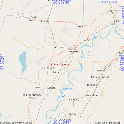
Goth Garelo GPS coordinates[2]
27° 26' 6.756" North, 68° 4' 32.592" East
| Map corner | latitude | longitude |
|---|---|---|
| Upper-left | 28.05748°, | 67.3726° |
| Center: | 27.43521°, | 68.07572° |
| Lower-right: | 26.80941°, | 68.77885° |
| Map W x H: | 138.8×138.8 km | = 86.2×86.2mi |
| max Lat: | 36.32162° ⇑78.1% North |
| Goth Garelo: | 27.43521° |
| min Lat: | ⇓21.9% South 24.14422° |
| min Long | Goth Garelo | max Long |
| 61.74573° | 68.07572° | 75.63372° |
| W 13.3%⇐ | ⇒86.7% E |
Elevation
Elevation of Goth Garelo is 58 m = 190 ft, and this is 287 m = 942 ft below average elevation for this country.
| Max E: |
2732 m = 8963 ft | 77.4% |
| Avg. | 345 m = 1132 ft | |
| Goth Garelo | 58 m = 190 ft | |
Min E: |
3 m = 10 ft | 22.6% |
See also: Pakistan elevation on elevation.city.
Geographical zone
Goth Garelo is located in North temperate zone (between Tropic of Cancer and the Arctic Circle). Distance of this Northern Tropic circle is 444.6 km =276.3 mi to South.| Distance of | km | miles | from Goth Garelo |
|---|---|---|---|
| North Pole | 6956.6 | 4322.6 | to North |
| Arctic Circle | 4350.7 | 2703.4 | to North |
| Tropic Cancer | 444.6 | 276.3 | to South |
| Equator | 3050.5 | 1895.5 | to South |


Nearby cities:
15 places around Goth Garelo: (largest is in red/bold)
• Dokri
7.1 km =4.4 mi,  162°
162°
• Gambat
45 km =28 mi,  101°
101°
• Goth Radhan
29 km =18 mi,  204°
204°
• Hingorja
41.9 km =26 mi,  126°
126°
• Kambar
18.5 km =11.5 mi,  336°
336°
• Kandiaro
43.9 km =27.3 mi, 162°
• Larkana
19.2 km =11.9 mi,  44°
44°
• Mehar
37.9 km =23.5 mi,  221°
221°
• Miro Khan
36.1 km =22.4 mi,  2°
2°
• Nasirabad
16.8 km =10.4 mi,  249°
249°
• Naudero
38.1 km =23.7 mi,  47°
47°
• New Bādāh
11.3 km =7 mi, 202°
• Ranipur
45.6 km =28.3 mi,  111°
111°
• Sobhodero
34.9 km =21.7 mi, 114°
• Warah
27.6 km =17.1 mi,  272°
272°
Sources, notices
• [Note1] Compared only with cities in Pakistan existing in our database
• [Src1] Map data: © OpenStreetMap contributors (CC-BY-SA)
• [Src2] Other city data from geonames.org with taken over terms of usage.
• [Src3] Geographical zone / Annual Mean Temperature by Robert A. Rohde @ Wikipedia
