Duki geodata
Duki (Balochistan) is a populated place; located in Pakistan in Asia/Karachi (GMT+5) time zone. With population of 6,384 people, there are 382 cities with bigger population in this country. Compared to other cities in Pakistan, 57.8% of cities are located further ↑North; 77% of cities are located further →East and 90.7% of cities have lower elevation than Duki. Note1


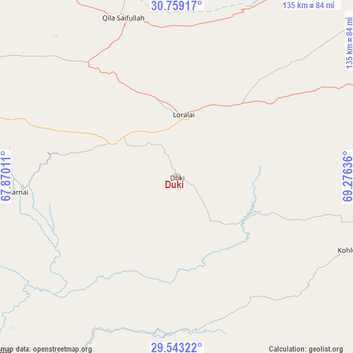
Duki GPS coordinates[2]
30° 9' 11.052" North, 68° 34' 23.628" East
| Map corner | latitude | longitude |
|---|---|---|
| Upper-left | 30.75917°, | 67.87011° |
| Center: | 30.15307°, | 68.57323° |
| Lower-right: | 29.54322°, | 69.27636° |
| Map W x H: | 135.2×135.2 km | = 84×84mi |
| max Lat: | 36.32162° ⇑57.8% North |
| Duki: | 30.15307° |
| min Lat: | ⇓42.2% South 24.14422° |
| min Long | Duki | max Long |
| 61.74573° | 68.57323° | 75.63372° |
| W 23%⇐ | ⇒77% E |
Elevation
Elevation of Duki is 1092 m = 3583 ft, and this is 747 m = 2451 ft above average elevation for this country.
| Max E: |
2732 m = 8963 ft | 9.3% |
| Duki | 1092 m 3583 ft | |
| Avg. | 345 m = 1132 ft | |
Min E: |
3 m = 10 ft | 90.7% |
See also: Pakistan elevation on elevation.city.
Geographical zone
Duki is located in North temperate zone (between Tropic of Cancer and the Arctic Circle). Distance of this Northern Tropic circle is 746.8 km =464 mi to South.| Distance of | km | miles | from Duki |
|---|---|---|---|
| North Pole | 6654.4 | 4134.9 | to North |
| Arctic Circle | 4048.5 | 2515.6 | to North |
| Tropic Cancer | 746.8 | 464 | to South |
| Equator | 3352.7 | 2083.3 | to South |


Nearby cities:
15 places around Duki: (largest is in red/bold)
• Alik Ghund
107.6 km =66.9 mi,  290°
290°
• Barkhan
96 km =59.7 mi,  107°
107°
• Bhag
143.2 km =89 mi,  210°
210°
• Dadhar
116.6 km =72.5 mi,  229°
229°
• Dera Bugti
136.5 km =84.8 mi,  155°
155°
• Harnai
61.3 km =38.1 mi,  264°
264°
• Khadan Khak
106.1 km =65.9 mi,  308°
308°
• Kohlu
71.4 km =44.4 mi, 113°
• Loralai
24.3 km =15.1 mi,  5°
5°
• Mach
123.9 km =77 mi,  254°
254°
• Musa Khel Bazar
143.1 km =88.9 mi,  56°
56°
• Qila Saifullah
64.2 km =39.9 mi,  341°
341°
• Quetta
151.1 km =93.9 mi,  271°
271°
• Sibi
95.4 km =59.3 mi,  224°
224°
• Ziarat
85.3 km =53 mi, 287°
Sources, notices
• [Note1] Compared only with cities in Pakistan existing in our database
• [Src1] Map data: © OpenStreetMap contributors (CC-BY-SA)
• [Src2] Other city data from geonames.org with taken over terms of usage.
• [Src3] Geographical zone / Annual Mean Temperature by Robert A. Rohde @ Wikipedia
