Loralai geodata
Loralai (Balochistan) is a seat of a second-order administrative division; located in Pakistan in Asia/Karachi (GMT+5) time zone. With population of 37,787 people, there are 164 cities with bigger population in this country. Compared to other cities in Pakistan, 55.5% of cities are located further ↑North; 76.7% of cities are located further →East and 94.6% of cities have lower elevation than Loralai. Note1


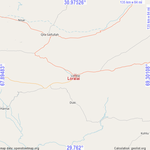
Loralai GPS coordinates[2]
30° 22' 13.836" North, 68° 35' 52.62" East
| Map corner | latitude | longitude |
|---|---|---|
| Upper-left | 30.97526°, | 67.89483° |
| Center: | 30.37051°, | 68.59795° |
| Lower-right: | 29.762°, | 69.30108° |
| Map W x H: | 134.9×134.9 km | = 83.8×83.8mi |
| max Lat: | 36.32162° ⇑55.5% North |
| Loralai: | 30.37051° |
| min Lat: | ⇓44.5% South 24.14422° |
| min Long | Loralai | max Long |
| 61.74573° | 68.59795° | 75.63372° |
| W 23.3%⇐ | ⇒76.7% E |
Elevation
Elevation of Loralai is 1440 m = 4724 ft, and this is 1095 m = 3593 ft above average elevation for this country.
| Max E: |
2732 m = 8963 ft | 5.4% |
| Loralai | 1440 m 4724 ft | |
| Avg. | 345 m = 1132 ft | |
Min E: |
3 m = 10 ft | 94.6% |
See also: Pakistan elevation on elevation.city.
Geographical zone
Loralai is located in North temperate zone (between Tropic of Cancer and the Arctic Circle). Distance of this Northern Tropic circle is 771 km =479.1 mi to South.| Distance of | km | miles | from Loralai |
|---|---|---|---|
| North Pole | 6630.2 | 4119.8 | to North |
| Arctic Circle | 4024.3 | 2500.6 | to North |
| Tropic Cancer | 771 | 479.1 | to South |
| Equator | 3376.9 | 2098.3 | to South |


Nearby cities:
15 places around Loralai: (largest is in red/bold)
• Alik Ghund
104 km =64.6 mi,  277°
277°
• Barkhan
103.5 km =64.3 mi,  120°
120°
• Dadhar
135 km =83.9 mi,  222°
222°
• Duki
24.3 km =15.1 mi,  185°
185°
• Harnai
70.1 km =43.6 mi,  244°
244°
• Khadan Khak
94.9 km =59 mi,  296°
296°
• Kohlu
82.1 km =51 mi,  129°
129°
• Mach
134.3 km =83.5 mi,  245°
245°
• Musa Khel Bazar
129.1 km =80.2 mi,  65°
65°
• Pishin
155.5 km =96.6 mi, 278°
• Qila Saifullah
43.2 km =26.8 mi,  328°
328°
• Quetta
154.7 km =96.1 mi,  262°
262°
• Sibi
115.3 km =71.6 mi, 217°
• Zhob
135.1 km =83.9 mi,  36°
36°
• Ziarat
83.7 km =52 mi,  270°
270°
Sources, notices
• [Note1] Compared only with cities in Pakistan existing in our database
• [Src1] Map data: © OpenStreetMap contributors (CC-BY-SA)
• [Src2] Other city data from geonames.org with taken over terms of usage.
• [Src3] Geographical zone / Annual Mean Temperature by Robert A. Rohde @ Wikipedia
