Mach geodata
Mach (Balochistan) is a populated place; located in Pakistan in Asia/Karachi (GMT+5) time zone. With population of 16,930 people, there are 292 cities with bigger population in this country. Compared to other cities in Pakistan, 60% of cities are located further ↑North; 94.6% of cities are located further →East and 88.5% of cities have lower elevation than Mach. Note1


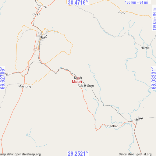
Mach GPS coordinates[2]
29° 51' 49.356" North, 67° 19' 48.648" East
| Map corner | latitude | longitude |
|---|---|---|
| Upper-left | 30.4716°, | 66.62706° |
| Center: | 29.86371°, | 67.33018° |
| Lower-right: | 29.2521°, | 68.03331° |
| Map W x H: | 135.6×135.6 km | = 84.3×84.3mi |
| max Lat: | 36.32162° ⇑60% North |
| Mach: | 29.86371° |
| min Lat: | ⇓40% South 24.14422° |
| min Long | Mach | max Long |
| 61.74573° | 67.33018° | 75.63372° |
| W 5.4%⇐ | ⇒94.6% E |
Elevation
Elevation of Mach is 977 m = 3205 ft, and this is 632 m = 2073 ft above average elevation for this country.
| Max E: |
2732 m = 8963 ft | 11.5% |
| Mach | 977 m 3205 ft | |
| Avg. | 345 m = 1132 ft | |
Min E: |
3 m = 10 ft | 88.5% |
See also: Pakistan elevation on elevation.city.
Geographical zone
Mach is located in North temperate zone (between Tropic of Cancer and the Arctic Circle). Distance of this Northern Tropic circle is 714.6 km =444 mi to South.| Distance of | km | miles | from Mach |
|---|---|---|---|
| North Pole | 6686.5 | 4154.8 | to North |
| Arctic Circle | 4080.6 | 2535.6 | to North |
| Tropic Cancer | 714.6 | 444 | to South |
| Equator | 3320.5 | 2063.3 | to South |


Nearby cities:
15 places around Mach: (largest is in red/bold)
• Alik Ghund
72 km =44.7 mi,  14°
14°
• Bhag
103.1 km =64.1 mi,  152°
152°
• Dadhar
53.2 km =33.1 mi,  144°
144°
• Duki
123.9 km =77 mi,  74°
74°
• Harnai
64.2 km =39.9 mi, 65°
• Kalat
117.3 km =72.9 mi,  217°
217°
• Khadan Khak
105.4 km =65.5 mi,  20°
20°
• Kot Malik Barkhurdar
50.2 km =31.2 mi,  318°
318°
• Mastung
47.3 km =29.4 mi,  261°
261°
• Nushki
130.9 km =81.3 mi,  254°
254°
• Pishin
86.1 km =53.5 mi,  337°
337°
• Qila Abdullah
115.6 km =71.8 mi,  326°
326°
• Quetta
47.7 km =29.6 mi, 318°
• Sibi
63.7 km =39.6 mi,  124°
124°
• Ziarat
69.1 km =42.9 mi,  33°
33°
Sources, notices
• [Note1] Compared only with cities in Pakistan existing in our database
• [Src1] Map data: © OpenStreetMap contributors (CC-BY-SA)
• [Src2] Other city data from geonames.org with taken over terms of usage.
• [Src3] Geographical zone / Annual Mean Temperature by Robert A. Rohde @ Wikipedia
