Harnai geodata
Harnai (Balochistan) is a populated place; located in Pakistan in Asia/Karachi (GMT+5) time zone. With population of 11,066 people, there are 344 cities with bigger population in this country. Compared to other cities in Pakistan, 58% of cities are located further ↑North; 88.9% of cities are located further →East and 87.4% of cities have lower elevation than Harnai. Note1


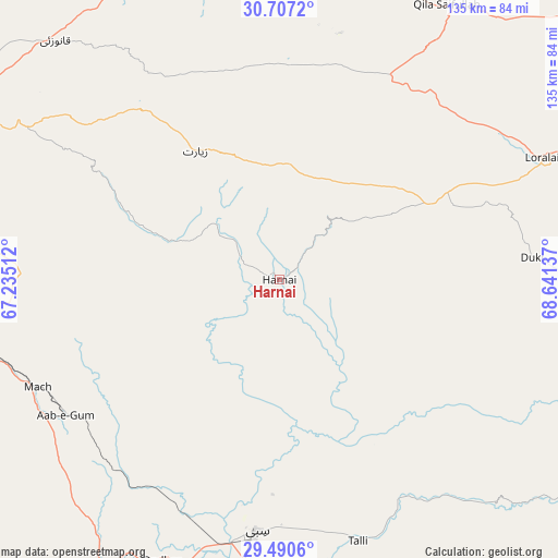
Harnai GPS coordinates[2]
30° 6' 2.772" North, 67° 56' 17.664" East
| Map corner | latitude | longitude |
|---|---|---|
| Upper-left | 30.7072°, | 67.23512° |
| Center: | 30.10077°, | 67.93824° |
| Lower-right: | 29.4906°, | 68.64137° |
| Map W x H: | 135.3×135.3 km | = 84.1×84.1mi |
| max Lat: | 36.32162° ⇑58% North |
| Harnai: | 30.10077° |
| min Lat: | ⇓42% South 24.14422° |
| min Long | Harnai | max Long |
| 61.74573° | 67.93824° | 75.63372° |
| W 11.1%⇐ | ⇒88.9% E |
Elevation
Elevation of Harnai is 903 m = 2963 ft, and this is 558 m = 1831 ft above average elevation for this country.
| Max E: |
2732 m = 8963 ft | 12.6% |
| Harnai | 903 m 2963 ft | |
| Avg. | 345 m = 1132 ft | |
Min E: |
3 m = 10 ft | 87.4% |
See also: Pakistan elevation on elevation.city.
Geographical zone
Harnai is located in North temperate zone (between Tropic of Cancer and the Arctic Circle). Distance of this Northern Tropic circle is 741 km =460.4 mi to South.| Distance of | km | miles | from Harnai |
|---|---|---|---|
| North Pole | 6660.2 | 4138.5 | to North |
| Arctic Circle | 4054.3 | 2519.2 | to North |
| Tropic Cancer | 741 | 460.4 | to South |
| Equator | 3346.9 | 2079.7 | to South |


Nearby cities:
15 places around Harnai: (largest is in red/bold)
• Alik Ghund
58.9 km =36.6 mi,  317°
317°
• Bhag
118.3 km =73.5 mi,  185°
185°
• Dadhar
74.9 km =46.5 mi,  201°
201°
• Duki
61.3 km =38.1 mi,  84°
84°
• Khadan Khak
75.6 km =47 mi,  343°
343°
• Kohlu
128.6 km =79.9 mi,  100°
100°
• Kot Malik Barkhurdar
92.1 km =57.2 mi,  277°
277°
• Loralai
70.1 km =43.6 mi,  64°
64°
• Mach
64.2 km =39.9 mi,  245°
245°
• Mastung
110.5 km =68.7 mi, 252°
• Pishin
105.2 km =65.4 mi,  300°
300°
• Qila Saifullah
78 km =48.5 mi,  31°
31°
• Quetta
90.6 km =56.3 mi, 275°
• Sibi
62.3 km =38.7 mi, 185°
• Ziarat
37.4 km =23.2 mi,  326°
326°
Sources, notices
• [Note1] Compared only with cities in Pakistan existing in our database
• [Src1] Map data: © OpenStreetMap contributors (CC-BY-SA)
• [Src2] Other city data from geonames.org with taken over terms of usage.
• [Src3] Geographical zone / Annual Mean Temperature by Robert A. Rohde @ Wikipedia
