Ziarat geodata
Ziarat (Balochistan) is a seat of a second-order administrative division; located in Pakistan in Asia/Karachi (GMT+5) time zone. With population of 733 people, there are 414 cities with bigger population in this country. Compared to other cities in Pakistan, 55.3% of cities are located further ↑North; 92.1% of cities are located further →East and 99.5% of cities have lower elevation than Ziarat. Note1


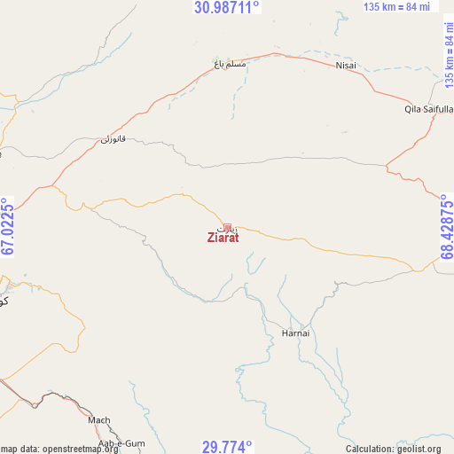
Ziarat GPS coordinates[2]
30° 22' 56.784" North, 67° 43' 32.232" East
| Map corner | latitude | longitude |
|---|---|---|
| Upper-left | 30.98711°, | 67.0225° |
| Center: | 30.38244°, | 67.72562° |
| Lower-right: | 29.774°, | 68.42875° |
| Map W x H: | 134.9×134.9 km | = 83.8×83.8mi |
| max Lat: | 36.32162° ⇑55.3% North |
| Ziarat: | 30.38244° |
| min Lat: | ⇓44.7% South 24.14422° |
| min Long | Ziarat | max Long |
| 61.74573° | 67.72562° | 75.63372° |
| W 7.9%⇐ | ⇒92.1% E |
Elevation
Elevation of Ziarat is 2433 m = 7982 ft, and this is 2088 m = 6850 ft above average elevation for this country.
| Max E: |
2732 m = 8963 ft | 0.5% |
| Ziarat | 2433 m 7982 ft | |
| Avg. | 345 m = 1132 ft | |
Min E: |
3 m = 10 ft | 99.5% |
See also: Pakistan elevation on elevation.city.
Geographical zone
Ziarat is located in North temperate zone (between Tropic of Cancer and the Arctic Circle). Distance of this Northern Tropic circle is 772.3 km =479.9 mi to South.| Distance of | km | miles | from Ziarat |
|---|---|---|---|
| North Pole | 6628.9 | 4119 | to North |
| Arctic Circle | 4023 | 2499.8 | to North |
| Tropic Cancer | 772.3 | 479.9 | to South |
| Equator | 3378.2 | 2099.1 | to South |


Nearby cities:
15 places around Ziarat: (largest is in red/bold)
• Alik Ghund
22.9 km =14.2 mi,  301°
301°
• Chaman
135.5 km =84.2 mi, 296°
• Dadhar
101.2 km =62.9 mi,  184°
184°
• Duki
85.3 km =53 mi,  107°
107°
• Harnai
37.4 km =23.2 mi,  146°
146°
• Khadan Khak
41.2 km =25.6 mi,  358°
358°
• Kot Malik Barkhurdar
73.6 km =45.7 mi,  254°
254°
• Loralai
83.7 km =52 mi,  90°
90°
• Mach
69.1 km =42.9 mi,  213°
213°
• Mastung
106.6 km =66.2 mi,  232°
232°
• Pishin
73.5 km =45.7 mi,  287°
287°
• Qila Abdullah
108.9 km =67.7 mi, 290°
• Qila Saifullah
70.3 km =43.7 mi,  59°
59°
• Quetta
72.9 km =45.3 mi, 252°
• Sibi
94.5 km =58.7 mi,  171°
171°
Sources, notices
• [Note1] Compared only with cities in Pakistan existing in our database
• [Src1] Map data: © OpenStreetMap contributors (CC-BY-SA)
• [Src2] Other city data from geonames.org with taken over terms of usage.
• [Src3] Geographical zone / Annual Mean Temperature by Robert A. Rohde @ Wikipedia
