Barkhan geodata
Barkhan (Balochistan) is a seat of a second-order administrative division; located in Pakistan in Asia/Karachi (GMT+5) time zone. With population of 8,760 people, there are 365 cities with bigger population in this country. Compared to other cities in Pakistan, 59.4% of cities are located further ↑North; 65.9% of cities are located further →East and 91% of cities have lower elevation than Barkhan. Note1


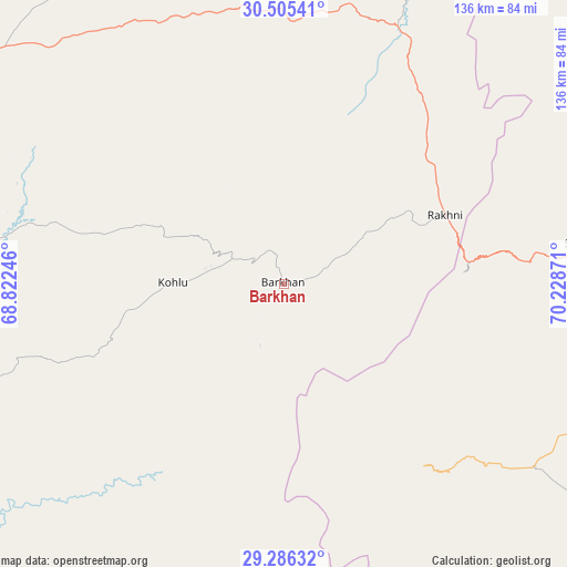
Barkhan GPS coordinates[2]
29° 53' 51.828" North, 69° 31' 32.088" East
| Map corner | latitude | longitude |
|---|---|---|
| Upper-left | 30.50541°, | 68.82246° |
| Center: | 29.89773°, | 69.52558° |
| Lower-right: | 29.28632°, | 70.22871° |
| Map W x H: | 135.6×135.6 km | = 84.3×84.3mi |
| max Lat: | 36.32162° ⇑59.4% North |
| Barkhan: | 29.89773° |
| min Lat: | ⇓40.6% South 24.14422° |
| min Long | Barkhan | max Long |
| 61.74573° | 69.52558° | 75.63372° |
| W 34.1%⇐ | ⇒65.9% E |
Elevation
Elevation of Barkhan is 1100 m = 3609 ft, and this is 755 m = 2477 ft above average elevation for this country.
| Max E: |
2732 m = 8963 ft | 9% |
| Barkhan | 1100 m 3609 ft | |
| Avg. | 345 m = 1132 ft | |
Min E: |
3 m = 10 ft | 91% |
See also: Pakistan elevation on elevation.city.
Geographical zone
Barkhan is located in North temperate zone (between Tropic of Cancer and the Arctic Circle). Distance of this Northern Tropic circle is 718.4 km =446.4 mi to South.| Distance of | km | miles | from Barkhan |
|---|---|---|---|
| North Pole | 6682.7 | 4152.4 | to North |
| Arctic Circle | 4076.9 | 2533.3 | to North |
| Tropic Cancer | 718.4 | 446.4 | to South |
| Equator | 3324.3 | 2065.6 | to South |


Nearby cities:
15 places around Barkhan: (largest is in red/bold)
• Alipur
145.6 km =90.5 mi,  113°
113°
• Dajal
90.4 km =56.2 mi, 114°
• Dera Bugti
102.2 km =63.5 mi,  200°
200°
• Dera Ghazi Khan
108.6 km =67.5 mi,  81°
81°
• Duki
96 km =59.7 mi,  287°
287°
• Jampur
107.1 km =66.5 mi, 105°
• Jatoi Shimali
134.2 km =83.4 mi, 108°
• Kohlu
26.3 km =16.3 mi,  269°
269°
• Loralai
103.5 km =64.3 mi,  300°
300°
• Musa Khel Bazar
110.6 km =68.7 mi,  14°
14°
• Qila Saifullah
143.2 km =89 mi,  308°
308°
• Rajanpur
117.7 km =73.1 mi,  138°
138°
• Rojhan
140.8 km =87.5 mi,  162°
162°
• Shahr Sultan
148.9 km =92.5 mi,  103°
103°
• Taunsa
140.3 km =87.2 mi,  50°
50°
Sources, notices
• [Note1] Compared only with cities in Pakistan existing in our database
• [Src1] Map data: © OpenStreetMap contributors (CC-BY-SA)
• [Src2] Other city data from geonames.org with taken over terms of usage.
• [Src3] Geographical zone / Annual Mean Temperature by Robert A. Rohde @ Wikipedia
